The Archaeology of Rich Neck Plantation (44WB52): Description of the Features
Colonial Williamsburg Foundation Library Research Report Series - 0386
Colonial Williamsburg Foundation Library
Williamsburg, Virginia
2009
The Archaeology of Rich Neck Plantation (44WB52): Description of the Features
The Colonial Williamsburg Foundation
Department of Archaeological Research
P.O. Box 1776
Williamsburg, VA 23187-1776
(757) 220-7330
Marley R. Brown III
Principal Investigator
January 2003
| Page | |
| Chapter 1. Introduction | 1 |
| The Site | 8 |
| Chapter 2. George Menefie Ownership (ca. 1635-1636) | 11 |
| Chapter 3. Richard and Elizabeth Kemp Ownership (1636-1650) | 15 |
| Archaeological Features | 17 |
| Structure A (Richard Kemp's dwelling house) | 17 |
| Structure B (The Kitchen) | 21 |
| Kiln | 23 |
| Enclosures | 26 |
| Refuse Middens | 31 |
| Discussion | 31 |
| Structures Made of Brick | 31 |
| Protection | 32 |
| Landscape Design | 33 |
| Chapter 4. Sir Thomas and Lady Elizabeth Lunsford Ownership (1650-1653) | 37 |
| Archaeological Features | 40 |
| Structure G (Agricultural Shed) | 40 |
| Enclosures | 42 |
| Discussion | 43 |
| Chapter 5. Thomas Ludwell Ownership (1665-1677) | 47 |
| Archaeological Features | 48 |
| Structure A (Thomas Ludwell's Dwelling) | 49 |
| Kitchen/Quarter/Workspace | 52 |
| The Additions | 60 |
| Discussion | 66 |
| Post Structures | 66 |
| Structure D | 70 |
| Structures E and F | 71 |
| Structure H | 73 |
| Watering Hole | 75 |
| The Human Burial | 75 |
| Enclosures | 77 |
| Trash Disposal | 77 |
| Discussion | 77 |
| Grazing Area | 79 |
| Structure H | 79 |
| Courtyard Plan | 85 |
| ii | |
| Chapter 6. Philip Ludwell/Philip Ludwell II Occpancy and Ownership (1674-1694) | 87 |
| Archaeological Features | 87 |
| Dwelling House | 87 |
| The Rest of the Site | 89 |
| Discussion | 90 |
| Afterword | 93 |
| References | 95 |
| Appendix 1. Description of the Rich Neck Burial | 99 |
| Page | |
| 1.Rich Neck site before excavation | 1 |
| 2.Logging truck driving through the site | 2 |
| 3.Students working on site | 3 |
| 4.Single 1 meter square | 5 |
| 5.Removal of 25 percent of the plowzone | 6 |
| 6.Removal of 50 percent of the plowzone | 6 |
| 7.Removal of all of the plowzone | 7 |
| 8.Excavation areas | 7 |
| 9.Rich Neck Plantation | 8 |
| 10.Features discovered at Rich Neck | 9 |
| 11.Typical stratigraphy | 9 |
| 12.Middle Plantation | 11 |
| 13.Three sites found near Archers Hope Creek | 13 |
| 14.Kemp's Rich Neck plat | 15 |
| 15.Kemp's Jamestown House | 16 |
| 16.Distribution of 9/64-inch diameter pipestems | 18 |
| 17.Kemp's Rich Neck | 18 |
| 18.Dwelling house | 19 |
| 19.Kemp's dwelling house | 19 |
| 20.Closeup of central fireplace | 20 |
| 21.Kitchen/quarter | 21 |
| 22.Kemp's portion of the kitchen | 22 |
| 23.Closeup of fireplace | 23 |
| 24.Closeup of bake oven | 24 |
| 25.John Page's brick kiln | 25 |
| 26.Half excavated small clay quarry pit | 25 |
| 27.Successful quarry pit | 26 |
| 28.First trench through quarry pit | 27 |
| 29.Slot fence connecting kitchen to main E-W fence | 27 |
| 30.Plan of garden area | 28 |
| 31.Plan view of planting hole | 29 |
| 32.Excavated section of bounding ditch | 29 |
| 33.Detail of main E-W fence | 30 |
| 34.Richard Kemp bottle seal | 31 |
| 35.Bartmann bottle | 31 |
| 36.John Page house | 32 |
| 37.Nassau Street cellar | 33 |
| 38.Landscape zones | 34 |
| iv | |
| 39.Distribution of flower pot fragments | 35 |
| 40.Overview of Page site | 36 |
| 41.Lunsford portrait | 37 |
| 42.Lunsford's Rich Neck | 40 |
| 43.Overview of Structure G | 41 |
| 44.Structure G | 42 |
| 45.Phytolith distribution | 44 |
| 46.Distribution of phosphorous | 44 |
| 47.Distribution of calcium | 44 |
| 48.Distribution of maize phytoliths | 44 |
| 49.Thomas Ludwell's Rich Neck | 47 |
| 50.Dwelling during Thomas Ludwell period | 49 |
| 51.Rear room additions | 50 |
| 52.Reconstruction of Rich Neck, circa 1670 | 50 |
| 53.Model of Rich Neck dwelling as a two-story structure | 51 |
| 54.Closeup of exterior chimney | 51 |
| 55.Fireplace tiles featuring children playing games | 52 |
| 56.Pantile roof | 53 |
| 57.Kitchen/quarter/work building | 53 |
| 58.Overall of kitchen | 54 |
| 59.Kitchen center room | 55 |
| 60.Closeup of root cellar showing postholes | 56 |
| 61.Detail of root cellar showing reinforcing postholes | 57 |
| 62.Detail of root cellar notches | 58 |
| 63.Detail of hearth floor before excavation | 59 |
| 64.Fireplace floor during excavation | 59 |
| 65.Fireplace floor after excavation | 61 |
| 66.South cellar overview | 62 |
| 67.Closeup of sump and brick pad | 63 |
| 68.North cellar overview | 63 |
| 69.Closeup of where stairs tied into floor | 65 |
| 70.Closeup of two work pits | 65 |
| 71.Distribution of plaster | 67 |
| 72.Distribution of curtain rings, candlesticks, and candlesnuffers | 67 |
| 73.Plan view of Structure C | 68 |
| 74.Overall of Structure C | 69 |
| 75.Plan view of Structure D | 70 |
| 76.Overall of Structure D | 71 |
| 77.Plan view of Structures E and F | 72 |
| 78.Overall of Structures E and F | 72 |
| v | |
| 79.Plan view of Structure H | 74 |
| 80.Overall of Structure H | 74 |
| 81.Plan view of watering hole | 76 |
| 82.Human burial | 76 |
| 83.Distribution of 7/64-inch diameter pipestems | 80 |
| 84.Paniciod distribution | 80 |
| 85.Chloridoid distribution | 81 |
| 86.Distribution of plaster around the dwelling | 81 |
| 87.Distribution of aiglets, curtain rings, locks, keys, and spurs around the dwelling | 82 |
| 88.Closeup of repairs to Structure H | 84 |
| 89.Overview of Ludwell's courtyard plan | 85 |
| 90.Philip/Philip II's Rich Neck | 85 |
| 91.Brick by brick of dwelling house | 86 |
| 92.Cellar of the last room added to the dwelling | 89 |
| 93.Pipe tamp | 90 |
| 94.Slot fences cutting Structure F posthole | 90 |
| 95.Location of Rich Neck's satellite slave quarter | 91 |
| 96.Overall of 1740s Rich Neck slave quarter | 92 |
| 97.John Coombs excavating Structure A cellar | 94 |
| 98.Excavating kitchen cellar | 94 |
| Page | |
| Table 1. Presence or absence of selected artifacts | 84 |
Chapter 1.
Introduction
In 1988, two boys found several artifacts while playing on a road construction site that was part of a new housing development (Figure 1). Accompanied by their parents, the boys brought their finds into Colonial Williamsburg's archaeology laboratory to see if the fragments were important. The curators at the lab are frequently called on to identify recently unearthed objects, most of which turn out to be modern castoffs. Once in a great while, however, someone comes in with an artifact that is an impressive example of colonial craftsmanship or that has a significant provenience. What the boys found fell into the latter category, and their visit would trigger a massive archaeological investigation that would take eight years to complete. It had been a long-standing research goal of Colonial Williamsburg's Department of Archaeological Research (D.A.R.) to investigate the colonial plantations that surrounded Williamsburg, and the date of manufacture for the artifacts found by the children indicated they had stumbled onto one. An excavation team dispatched to explore the housing development quickly uncovered other artifacts and architectural remains associated with a seventeenth-century plantation known as Rich Neck near where the boys were playing, as well as the remains of an early nineteenth-century slave quarter.
In 1992, McCale Development Corporation planned to develop the area as part of the Holly Hills residential development, and as part of their proffer to the city they contracted with the D.A.R. to evaluate the archaeological significance of the seventeenth-century site (Figure 2). Test units, placed at 10 meter intervals, uncovered several artifact concentrations and the remains of a brick foundation. That brickwork
 Figure 1. Rich Neck site before excavation.
2
Figure 1. Rich Neck site before excavation.
2
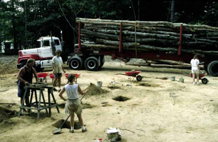 Figure 2. Logging truck driving through the site.
later proved to be only one of a number of structures located on Rich Neck's homelot (Muraca 1993). Even though the site had been plowed throughout the nineteenth century and later logged in the early 1900s, it was still in excellent shape.
Figure 2. Logging truck driving through the site.
later proved to be only one of a number of structures located on Rich Neck's homelot (Muraca 1993). Even though the site had been plowed throughout the nineteenth century and later logged in the early 1900s, it was still in excellent shape.
Recognizing the scale and importance of these findings, Colonial Williamsburg, the McCale Development Corporation, and the City of Williamsburg agreed to sponsor efforts to excavate the site. Colonial Williamsburg accordingly made plans to use its summer field school, run in conjunction with the College of William & Mary, to accomplish the task (Figure 3). The excavation was originally conceived as a salvage operation that would last only ten weeks. Midway through the summer, however, it became apparent that completion within this time frame was impossible given the growing size and complexity of the site. In response, McCale adjusted property boundaries so that the site's major components could be encompassed within two lots, which the City and Colonial Williamsburg then purchased and agreed to sell when the excavation was completed. The developer established two rules which were in effect for the entire dig. No machinery was to be used and no live trees with a diameter greater than 4 inches could be cut down.
With a new schedule in place, the field school spent the remainder of the first summer investigating features outside of the purchased lots, and after the field school was over, a professional crew continued this work for an additional two months. From 1994 through 2000 field schools returned to work at the site for ten weeks each summer. In 1998, Colonial Williamsburg sold its lot to individuals interested in preserving the site permanently. The city has just recently sold its parcel as well, but with a protective easement to shield the surviving architectural remains from destruction during the lot's development.
3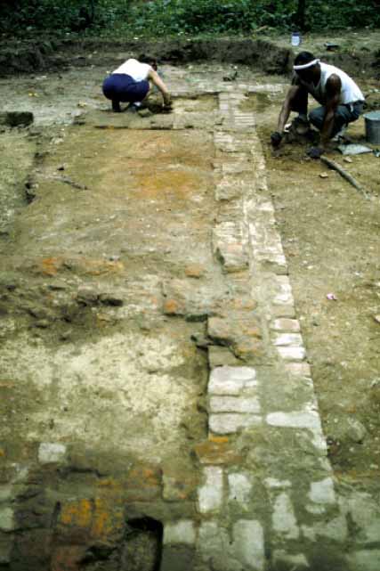 Figure 3. Students working on site.
Also found at the site was a slave quarter that was part of eighteenth-century Rich Neck. It was located on the northern edge of the seventeen-century complex and was excavated in 1994 and 1995 by Maria Franklin and Anna Agbe-Davies. Separate reports exist for these excavations (Franklin 1997; Agbe-Davies 1999).
Most of the initial salvage excavation focused on the area in the path of the development's main road. Plowed layers in this area were removed by machine, exposing numerous features including two post-in-ground structures, fences, a trash pit, and a man-made ditch—all of which were excavated. During these hectic first few weeks, field school students were instructed to hastily shovel away large areas of plowed soils without the benefit of screens in order to get at features that had survived underneath. Of course, both techniques resulted in a permanent loss of data, and after the time constraints were lifted a new excavation strategy was implemented that allowed plow zone material to be recovered over the rest of the site.
**********
Since the late 1970s, Chesapeake historical archaeologists have differed over what to do with plowed soils; an important question considering that almost all archaeological sites in the region have been plowed. Most Virginia archaeologists have argued that plowing damages cultural layers so thoroughly that any data contained within them is not worth the money required to implement recovery. They concluded that because 4 plowing had destroyed the relationship between artifacts and stratigraphic events (features and layers), such data was of limited value. They also argued that plowing physically moves artifacts away from their original location, reducing their validity as a dataset.
Most Maryland archaeologists took a different view. Beginning with the excavation of the St. John's site in St. Mary's City (1972-1976), plowzone sampling became an important element of their research designs. At St. John's, 29% of the plowzone was collected in 5-by-5 and 10-by-10 foot units (King 1988). Fraser Neiman recovered material from 120 10-by-10 foot squares of plowzone when he excavated the Clifts Plantation during the 1970s, and in 1984 and 1985 Dennis Pogue analyzed 144 2-by-2 meter squares at the King's Reach site (Pogue 1988). Subsequently, plowzone excavation has become standard practice for many Maryland archaeologists (Riordan 1988; Luckenbach 1994).
Arguments for plowzone excavation incorporated two distinct lines of reasoning. First, several studies indicated that most plowing generally did not move artifacts very much (Baker 1978; Lewarch and O'Brien 1981), and instead caused only slight movement of artifacts in large features such as sheet refuse and midden layers (Riordan 1988). Second, the same studies concluded that evidence of some past activities survived only in the plowzone and that its removal using machines resulted in significant data loss. Examples of research questions that could be asked of plowzone data include tracking temporal shifts in refuse disposal (Pogue 1988), identifying the location and organizational structure of past activities (King 1988), recovering destroyed architectural details (primarily door and window locations) (Keeler 1978), and understanding social relationships (Neiman 1980). These archaeologists argued that the best way to gain insight into how early Chesapeake settlers organized and used their space is to examine how the distribution of artifacts found in the plowzone relate to surviving features, and that while site plans provide a blueprint for understanding the spatial organization of a site, they are of limited value without examining the artifacts found near features. Collectively these researchers made a compelling argument that excavating plowed soils is the best way to understand, among other things, social relationships between masters, servants, and slaves—one of the main research goals of Chesapeake archaeology. Accordingly, in June 1993, we decided to excavate as much plowzone as possible.
Once the decision to recover plowed soils was made, the next issue the D.A.R. confronted was what size excavation unit to employ. As several studies have demonstrated, one of principal benefits of analyzing plowed soils is the potential to uncover discrete activities that are not otherwise apparent, one example being the location of a structure's windows and exterior doors. By examining the distribution of artifacts in the plowzone, it is often possible to identify where such architectural elements were once located even though no other physical evidence has survived. Believing that two-meter squares were too large to capture artifact concentrations in sufficient detail, we decided to excavate using one-meter squares.
Our plowzone sampling strategy developed over the first few summers, becoming more structured as time passed. Each summer we selected an area to excavate, with block size determined by the number of excavators and the complexity of the area. 5 Another factor that influenced what block size we selected was the nature of the field school itself. It would have been inappropriate for students to spend all of their time shoveling plowzone. The goal was to have the students spend the first half of the semester learning our excavation and recording system along with developing their digging skills by removing plowzone. Once these skills were in place, they turned their attention to the more complicated task of excavating features during the second half of the course.
The plowzone sampling procedure involved four steps. First, 25% of a selected area's plowzone was removed in one meter squares (Figures 4 and 5). Data recovered during this stage was put into Surfer®, a software program designed to predict total distribution of artifacts based on a sample. Second, unless an area was completely devoid of artifacts and features, an additional 25% of the plowzone was removed in one meter squares (Figure 6). Third, in areas that contained heavy concentrations of either artifacts or features, another 25% sample was collected. Finally, in areas containing important features all of the plowzone was excavated (Figure 7). Overall, 1300 one-meter-squares of plowzone were excavated within the roughly three acres that make up the entire site, the vast majority concentrated within the one acre surrounding the major buildings.
In seven field seasons, over 450 students, volunteers, and graduate teaching assistants worked on the site (Figure 8). They excavated almost 5000 contexts, nearly 2000 of which were plowzone (on parts of the site two layers of plowzone were encountered, resulting in a larger number of plowzone contexts that there were squares). Over 160,000 artifacts were collected, washed and identified.
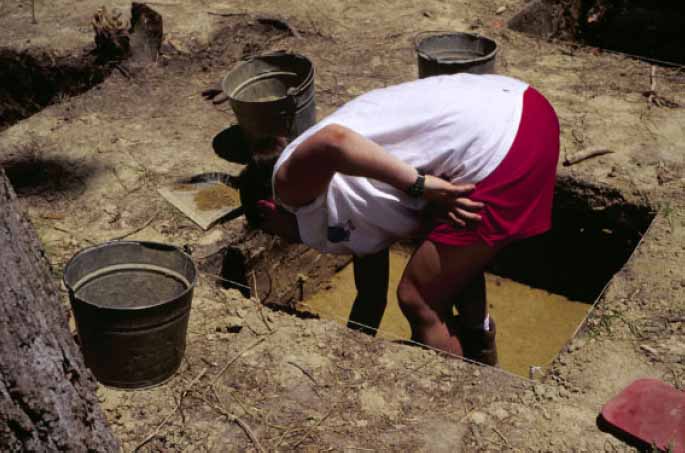 Figure 4. Excavation of a single 1 meter square.
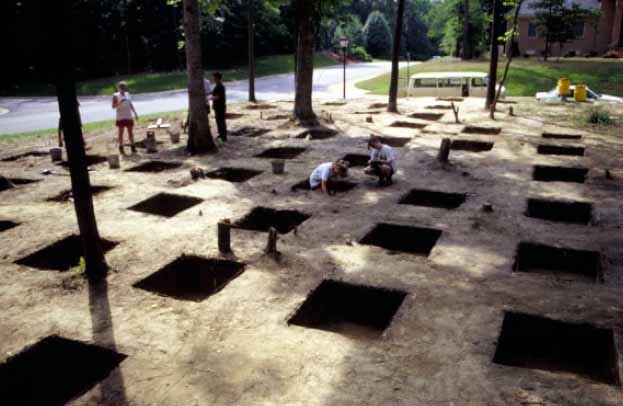 Figure 5. Removal of 25 percent of the plowzone.
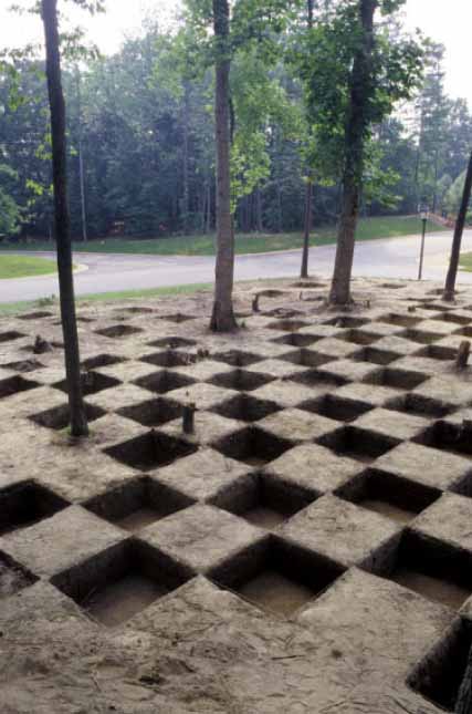 Figure 6. Removal of 50 percent of the plowzone.
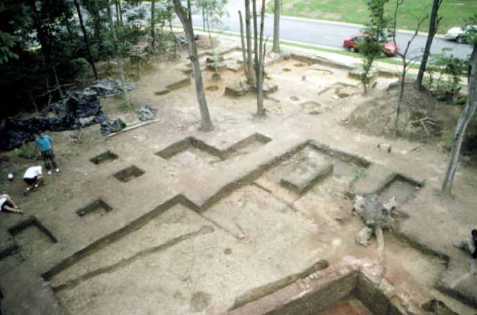 Figure 7. Removal of all of the plowzone.
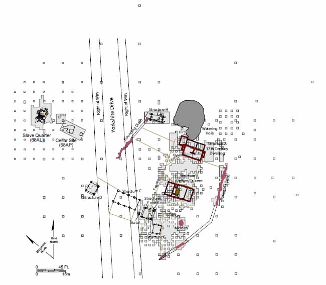 Figure 8. Excavation areas.
The Site
The Rich Neck site is located in the city of Williamsburg, Virginia, east of Jamestown Road, and in Phase I of the Holly Hills residential development (Figures 9 and 10). Designated as state site number 44WB52, the site lies geographically in the Atlantic Coastal Plain, where the topography is fairly level and low-lying, and rivers and major creeks are generally navigable. The James River is just two and a half miles south of Rich Neck, and is navigable from the sea as far west as Richmond. College Creek, a tributary of the James, is also about 3 4 mile due south. In the seventeenth century, before silt runoff from decades of farming closed the channel, College Creek was a viable thoroughfare for merchant ships.
Stratigraphy varied in different places on the site (Figure 11). Beneath a thin mat of decaying leaves and other vegetation, a dark grayish-brown loam extended 4 inches below the ground surface. This layer contained artifacts ranging in date from the seventeenth to the twentieth centuries. Most of the twentieth century artifacts represented mid-century logging activities and included such items as axe heads and discarded oil cans. The next two layers were part of a plowzone that sealed subsoil over most of the site. The top portion of plowzone was 4-8 inches thick and consisted of a brown to dark brown sandy loam characterized by an increasing density of artifacts and brick bits. Most artifacts in this layer dated to the seventeenth and eighteenth centuries. Over most of the site, the plowzone had an additional three-inch-thick layer of dark, yellowish-brown sandy loam that was more compacted than the overlying soil. Large
 Figure 9. Rich Neck Plantation.
9
Figure 9. Rich Neck Plantation.
9
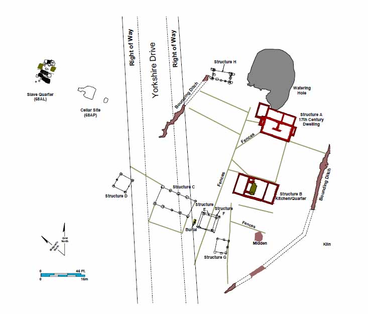 Figure 10. Features discovered at Rich Neck.
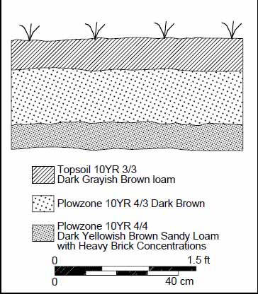 Figure 11. Typical stratigraphy.
10
brick concentrations appeared in this layer particularly around the site's two main structures, and the artifacts recovered from it were almost exclusively seventeenth century. Sterile subsoil was a pale brown sandy clay. In the northeast corner of the site a filled-in ravine added several stratigraphic layers to the sequence. Stratigraphy on the southwest side of the site was also more complicated as plowed layers built up in depth, in some places to almost a meter deep. Plowing and erosion seem to have altered the terrace by flattening the highest points and filling low spots.
Figure 11. Typical stratigraphy.
10
brick concentrations appeared in this layer particularly around the site's two main structures, and the artifacts recovered from it were almost exclusively seventeenth century. Sterile subsoil was a pale brown sandy clay. In the northeast corner of the site a filled-in ravine added several stratigraphic layers to the sequence. Stratigraphy on the southwest side of the site was also more complicated as plowed layers built up in depth, in some places to almost a meter deep. Plowing and erosion seem to have altered the terrace by flattening the highest points and filling low spots.
Though plowing effectively destroyed stratigraphic integrity, it had minimal impact on the archaeological remains that penetrated subsoil. In addition, most of the damage to the structural foundations occurred during the removal of the bricks for use in the construction of off-site buildings and a hearth at the nearby eighteenth-century slave quarter.
Soils at the site contributed to the overall favorable condition of the recovered artifacts. Most soils in Virginia are highly acidic, hastening the breakdown of organic and metallic objects. Calcium carbonates that counteract these acids are produced by decaying mollusk shells. At Rich Neck, decayed shell is present in the soil in the form of marl generated by underlying geologic shell beds commonly called the Yorktown formation. Oyster and clam shells discarded by native and Euro-American populations added to the neutralizing effect of the marl. These factors created an environment that slowed the decomposition of bone and metal to a remarkable degree. Pewter, for instance, was found in a state of preservation almost unparalleled on Virginia sites.
**********
The Director of the Department of Archaeological Research, Marley R. Brown III, served as principal investigator for the entire Rich Neck project. Various staff members who have overseen the field school excavations over the years included:
- 1993 ‒ Amy Kowalski Muraca, Leslie McFaden, and David Muraca
- 1994 ‒ Fred Smith and David Muraca
- 1995 ‒ Rob Galgano, Paul Moyer, Phil Levy, and David Muraca
- 1996 ‒ Phil Levy, Rob Galgano, and David Muraca
- 1997 ‒ Phil Levy, John Coombs, and David Muraca
- 1998 ‒ Phil Levy, John Coombs, and David Muraca
- 1999 ‒ no excavation
- 2000 ‒ Phil Levy, Dan Ingram, and Dave Muraca
Jennifer Jones, Leslie McFaden, and Paul Moyer conducted historical research . Laboratory Technicians Susan Wiard, Terri Keffert, Lee Priddy, Donna Sawyers, Isabel Jenkins, Susan Christie, and Lisa Fischer cataloged the finds and oversaw all artifact processing.
Specialist studies include a master's thesis by Kelly Ann Sullivan on environmental archaeology (William & Mary, Anthropology, 1999), portions of Dwayne Pickett's master's thesis on seventeenth-century brick structures (William & Mary, Anthropology, 1996), and John Coombs's dissertation on gentry slaveholders in seventeenth-century Chesapeake (William & Mary, History, 2001). As of summer 2001, both faunal analysis and cross-mending are underway.
Chapter 2.
George Menefie Ownership (ca. 1635-1636)
Rich Neck plantation was established on the western edge of the community known as Middle Plantation (Figure 12). At the time of Rich Neck's occupation during the second, third, and fourth quarters of the seventeenth century, Jamestown, or "James Cittie," the seat of government, was located some five miles to the southwest. During the century, English settlement in Virginia spread throughout the Tidewater from Lower Norfolk to the Northern Neck, including the Eastern Shore, but was restricted to east of the Fall Line.
Middle Plantation was first settled during the 1630s, when the colonial government ordered that a palisade be built spanning the peninsula between the James and York Rivers. This palisade was intended to clearly demarcate the line between Indian and English controlled territory, and its completion in 1634 encouraged several of Middle Plantation's early settlers to patent large tracts of land, giving the community a dispersed, patchwork appearance. Initially, most inhabitants clustered around the mouth of the creek, but eventually settlement expanded inward toward higher ground.
Middle Plantation started out in the hands of a few individuals, including John Utie, Humphrey Higgenson, Charles Leach, and Richard Popeley, all of whom owned large
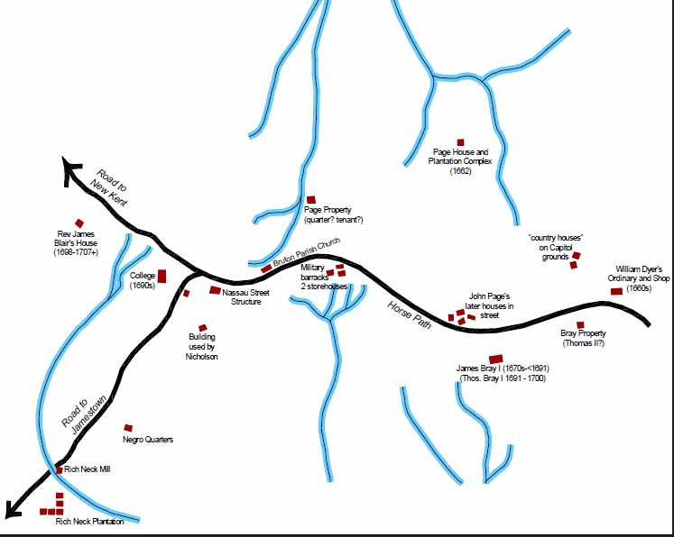 Figure 12. Middle Plantation.
12
plantations. The settlement grew as patents were issued for numerous smaller holdings of between 50 and 200 acres during the second half of the century, until by 1676 Middle Plantation was considered to be the center of the colony. Situated on the western fringe of this community, Rich Neck was one of the large sprawling estates patented early on.
Figure 12. Middle Plantation.
12
plantations. The settlement grew as patents were issued for numerous smaller holdings of between 50 and 200 acres during the second half of the century, until by 1676 Middle Plantation was considered to be the center of the colony. Situated on the western fringe of this community, Rich Neck was one of the large sprawling estates patented early on.
**********
The first person to patent the Rich Neck tract, George Menefie, arrived in Virginia in 1622 aboard the Samuell and soon established himself as a merchant and a colonial officeholder (Nugent 1979). The 1624 muster for the colony listed Menefie as having two servants and two houses, one of which was at Jamestown. Menefie served as a burgess for James City County in 1629, and by the time he patented Rich Neck six years later he was a member of the Governor's Council, an office he held until his death. As a merchant, he was also an agent for Englishmen who held estates in the colony. On July 2, 1635 he patented 1200 acres in James City County:
Being a neck of land comonly called the Rich Neck, bounded on the W. with a br. Of Archers Hope Cr. Which parts this from the barren Neck on E. with main br. Of sd. Cr. to the head, thence w on a direct line to the head of sd. br. (Nugent 1979)Menefie obtained the Rich Neck patent for the transportation of 24 immigrants, including an East Indian and a Turk (Nugent 1979).
Besides being one of the richest Virginians of his day, Menefie was one of the most important political figures in the early colony. Historian Martha McCartney believes that Menefie established his plantation seat at Rich Neck even before his 1635 patent. Like other members of the council, Menefie kept a house in Jamestown for use when that body was in session. His second home, called Littletown, was located just below Jamestown near Archers Hope Creek (present-day College Creek) (Figure 13). McCartney argues that sometime before March 1633, Menefie established Littletown somewhere on the Rich Neck tract. Even if true, archaeological evidence indicates that Menefie never lived at 44WB52. The artifacts suggest the site was first occupied in the early 1640s, not 1630. Out of the 7000 measurable pipestems recovered from the site, only 117 have bores that measure 9 64 inches or greater. The ratio of bores that measure 9 64ths to those that measure 8 64ths is 1 to 4.7. The ratios of 9/64ths to 8 64ths on two Martin's Hundred sites that were first occupied after 1625 are 1 to 2.1 and 1 to 2.6, suggesting that 44WB52 was settled at a later date than either. Surviving architectural remains also suggest that 44WB52 was originally settled later than 1630. The first structure built on the site was constructed completely of brick. The earliest known brick house built in Virginia was constructed ca. 1640 at Jamestown by Richard Kemp, four years after Menefie had sold Rich Neck (Horning 1995).
An archaeological survey of the rest of the Holly Hills development located three additional early colonial sites that may be related to Littletown (McFaden and Muraca 1993). A Phase II assessment of 44WB81 revealed an early seventeenth-century domestic complex with features and distinct artifact patterning. The complex appears to have included a post-in-ground building with wood and a clay (daub) chimney stack or smoke hood. The site's inhabitants had acquired status-related material goods, including a pedestaled salt cellar; a fluted glass container, probably French; at least
13
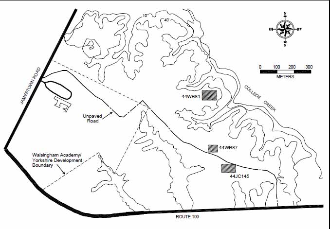 Figure 13. Three sites found near Archers Hope Creek may be remains of Menefie's Littletown.
one piece of cabinet furniture with drop-pull, copper alloy handles; and perhaps an item of table glass. In addition, there is evidence that improvements had been made to the dwelling house: brick paving probably lined the floor of a root cellar, and delft tiles appear to have adorned a hearth. A fragment of smoothed-surfaced granite points to further architectural embellishment such as a doorstep. Numerous pieces of round shot and the fastener from a piece of plate armor are reminders of the homestead's frontier status.
Figure 13. Three sites found near Archers Hope Creek may be remains of Menefie's Littletown.
one piece of cabinet furniture with drop-pull, copper alloy handles; and perhaps an item of table glass. In addition, there is evidence that improvements had been made to the dwelling house: brick paving probably lined the floor of a root cellar, and delft tiles appear to have adorned a hearth. A fragment of smoothed-surfaced granite points to further architectural embellishment such as a doorstep. Numerous pieces of round shot and the fastener from a piece of plate armor are reminders of the homestead's frontier status.
The Dutch ship captain David Peterson De Vries described an impressive garden planted by Menefie:
At noon, we came to Littleton, where we landed, and where there resided a great merchant, named Mr. Menefit, who kept us to dinner and treated us very well. The river is half as wide as before. Here was a garden of one morgen [two acres], full of Provence roses, apple, pear, and cherry trees, the various fruits of Holland, with different kinds of sweet-smelling herbs, such as rosemary, sage, marjoram, and thyme. Around the house were plenty of peach-trees, which were hardly in blossom. I was astonished to see this kind of tree, which I had never seen before on this coast. An express order came to us here, from the governor, who desired to see us, when we took our leave of the merchant, went aboard, and having weighed anchor, in two hours came to anchor before Jamestown, where the governor holds his court (DeVries 1971).
The existence of such an elaborate garden suggests that Menefie was a man invested in Virginia society who intended his stay in North America to be more than a temporary visit.
Menefie was not afraid to use his considerable political power, as witnessed by his participation in the ouster of Governor John Harvey (Billings 1975). In 1635, Governor Harvey was held in "house arrest" at Littletown while awaiting transport to 14 face charges in England. The next year Littletown hosted a meeting of the governor's council.
In 1639, Menefie was credited with the transportation of 60 individuals to Virginia, and in turn received 3000 acres on the north side of the York River. By the time of his death in 1646, Menefie had moved his residence to Buckland, an 8000 acre plantation in Charles City County.
Chapter 3. Richard and Elizabeth Kemp Ownership (1636-1650)
From almost the moment Secretary of the Colony Richard Kemp landed in Virginia, he became embroiled in a twenty-year political battle that profoundly shaped his new life in the colony. Born in 1600 to a prominent gentry family in Gissing, Norfolk, Richard was the third of seven sons born to Robert and Dorothy Kemp. When his father died in 1613, Robert Kemp Jr. took control of the family estate, leaving Richard and his other siblings with little choice but to adapt to life on an allowance (Virginia Magazine and History and Biography [hereafter VMHB] 20:73-74).
In search of employment that would maintain his position, Richard Kemp petitioned the King for a royal appointment. In 1634, the Crown rewarded Kemp with a position in Virginia, a small outpost known for Indian troubles, disease, and quarreling colonists (VMHB 8:160).
As Secretary, Kemp oversaw all correspondences that passed from colony to crown. He issued patents, commissions, charters, warrants, and licenses for marriage and other purposes. Additional duties included granting passes to leave the colony and
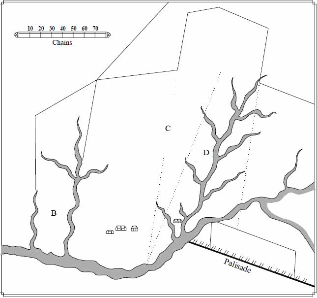 Figure 14. Kemp's Rich Neck plat. Drawn from 1642 survey by John Senior.
16
controlling the paperwork generated by Virginia's court system (Virginia General Court Decisions, August 1640; VMHB 5:367). The Secretary was permitted to collect fees for performing all of his numerous responsibilities, and received additional compensation in the form of servants and land as well.
Figure 14. Kemp's Rich Neck plat. Drawn from 1642 survey by John Senior.
16
controlling the paperwork generated by Virginia's court system (Virginia General Court Decisions, August 1640; VMHB 5:367). The Secretary was permitted to collect fees for performing all of his numerous responsibilities, and received additional compensation in the form of servants and land as well.
Kemp allied himself with the royal governor, Sir John Harvey, who at the time of Kemp's arrival was battling a group of local gentry planters for control of the colony. The tide of this struggle flowed back and forth, with one side appearing victorious only to be later bested by their opponents. Throughout this maneuvering, Kemp hung on to his position as Secretary. When Governor Harvey appeared be winning, Kemp helped punish his rivals. When the faction opposing Harvey appeared to be gaining the upper hand, Kemp maintained a low profile. The low point of Kemp's political career came in 1639, when Harvey was replaced as governor for the second time. Fearing a similar fate, Kemp secretly stowed away on a ship bound for England, where he pleaded his case to the King and was rewarded with the final triumph over his political enemies. In 1642, he returned to Virginia at the side of the new governor, Sir William Berkeley (Moyer n.d.).
In 1636, Kemp acquired Rich Neck from George Menefie, who had participated in the ouster of Governor Harvey. Around this time Kemp and his wife Elizabeth lived at Jamestown in a brick house which Harvey at one time described as "the fairest that ever was knowen in the countrye for substance and uniformitye" (Figure 15) (Nugent 1977; VMHB 3:29).
This house was recently re-excavated by Audrey Horning for the National Park Service. It is surprisingly similar to the dwelling Kemp later built at Rich Neck. First excavated in 1934, Kemp's Jamestown house was a lobby entrance hall and parlor measuring 25 by 34 feet. The bottom brick course of the foundation was made up of unmortared brick bats in no discernible pattern (Horning 1995). Because of Kemp's
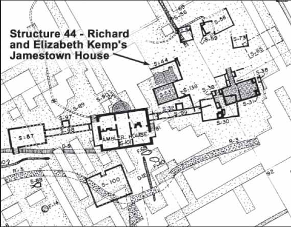 Figure 15. Kemp's Jamestown house. From Cotter 1958, Archeological Base Map of Jamestown.
17
political problems, he owned the house for only a short period of time. Richard and Elizabeth moved to Rich Neck around 1642, in part to escape the political infighting associated with Jamestown. As president of the council, Kemp briefly stood a stint as governor in 1644-45, before becoming ill in 1649. His will, written that year, bequeathed Rich Neck to his "deare and carefull" wife, and ordered her to sell the property and return to England. Kemp evidently died shortly thereafter, since several land patents issued in 1650 and 1651 referred to him as deceased (Nugent 1979). Kemp was credited with almost 100 headrights during his stay in Virginia, including 30 people of African origin.
Figure 15. Kemp's Jamestown house. From Cotter 1958, Archeological Base Map of Jamestown.
17
political problems, he owned the house for only a short period of time. Richard and Elizabeth moved to Rich Neck around 1642, in part to escape the political infighting associated with Jamestown. As president of the council, Kemp briefly stood a stint as governor in 1644-45, before becoming ill in 1649. His will, written that year, bequeathed Rich Neck to his "deare and carefull" wife, and ordered her to sell the property and return to England. Kemp evidently died shortly thereafter, since several land patents issued in 1650 and 1651 referred to him as deceased (Nugent 1979). Kemp was credited with almost 100 headrights during his stay in Virginia, including 30 people of African origin.
One of Kemp's final requests was that his body be buried in his orchard at Rich Neck (VMHB 1894(2):174). He certainly raised tobacco on some portion of the tract, and the ravine-cut woods adjacent to College Creek probably sheltered swine and cattle. His wish to be buried on the property was granted, according to an inscribed stone slab marking the grave of Thomas Ludwell, a later owner of the property. The slab was moved to Bruton Parish churchyard sometime before 1891 for safekeeping. It reads:
Under this Marble lieth the Body
of THOMAS LUDWELL Esqr
Secretary of Virginia, who was born
at Bruton in the County of SOMERSET
in the Kingdom of ENGLAND, and
departed this life in the Year 1678 And
near this place lye the Bodies of RICHARD
KEMP, esqr, his Predecessor in ye Secretarys
Office and Sr THOMAS LUNSFORD KT
in Memory of whom the Marble is placed
by the Order of Philip Ludwell esqr
Nephew of the said THOMAS LUDWELL
In the year 1727 (Anonymous 1911).
Archaeological Features
The archaeological remains dating from 1642 to 1650 include two brick structures, a bounding ditch, several clay quarry pits, a handful of fences, a brick kiln and several refuse middens (Figure 16).
Structure A (Richard Kemp's Dwelling House)
Structure A is the dwelling used by Richard and Elizabeth Kemp. All that remains of this structure is an intact brick foundation and two hearths. Oriented north-south along its long axis, the front of the house faced west. It was constructed as a single pile, hall and parlor with a central fireplace, and as built around 1642 measured 35 feet long by 20 feet wide. While no datable artifacts were found in the building's meager builder's trench, early pipestems (9 64ths or greater) cluster in and around what remains of its walls (Figure 17).
Brick foundations two and a half courses wide demarcate the initial building phase of Structure A (Figures 18 and 19). The width of this foundation and the large quantity
18
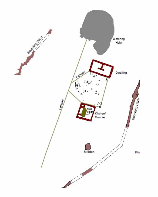 Figure 16. Kemp's Rich Neck.
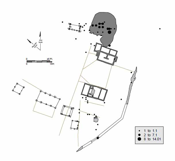 Figure 17. Distribution of 9/64-inch diameter pipestems.
19
Figure 17. Distribution of 9/64-inch diameter pipestems.
19
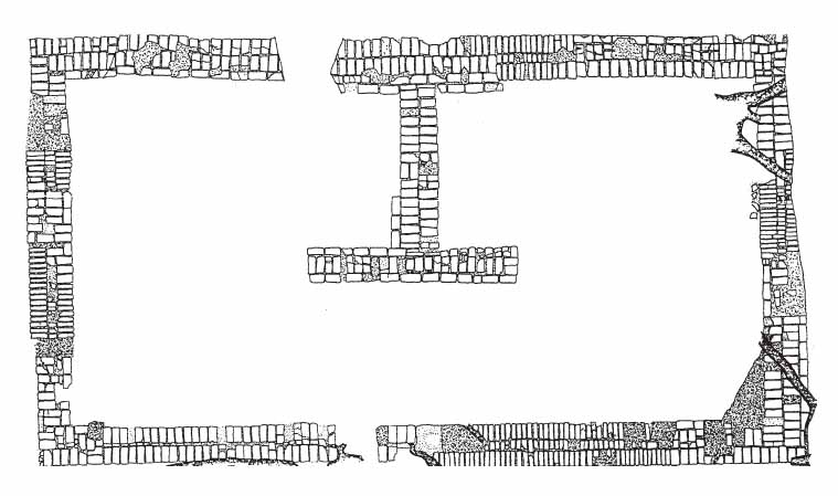 Figure 18. Dwelling house as originally built.
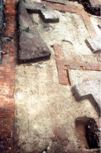 Figure 19. Kemp's dwelling house.
20
of brick found in the plowzone establishes that the structure was executed entirely in brick. The builder's trench was excavated revealing one to two courses of poorly made bricks. Excavation also uncovered an H-shaped chimney foundation, with opposing hearths facing north and south, thus dividing the interior space to two heated rooms (Figure 20). The fireplace is off-center, with the northernmost room measuring approximately 16 by 14.5 feet from interior wall to interior wall, and the south room roughly 16 by 10 feet. Because the fireplace also abutted the back (east) wall rather than lining up along the centerline or axis of the house, the chimney stack would have risen behind the ridge of the roof. This placement towards the back wall created extra room on the opposite side of the fireplace, so that there would have been perhaps six feet of space between the fireplace and the west wall of the house, where the front door was likely placed. The western cheek of the fireplace formed the back wall of this space, creating a lobby entrance roughly six and a half feet deep (east-west) by six feet wide, with doorways leading into the two downstairs rooms piercing its south and north walls. Structure A could have been either 1½ or 2 stories tall. A stairway connecting the downstairs with upstairs would have been located either in the lobby or in one of the downstairs rooms.
Figure 19. Kemp's dwelling house.
20
of brick found in the plowzone establishes that the structure was executed entirely in brick. The builder's trench was excavated revealing one to two courses of poorly made bricks. Excavation also uncovered an H-shaped chimney foundation, with opposing hearths facing north and south, thus dividing the interior space to two heated rooms (Figure 20). The fireplace is off-center, with the northernmost room measuring approximately 16 by 14.5 feet from interior wall to interior wall, and the south room roughly 16 by 10 feet. Because the fireplace also abutted the back (east) wall rather than lining up along the centerline or axis of the house, the chimney stack would have risen behind the ridge of the roof. This placement towards the back wall created extra room on the opposite side of the fireplace, so that there would have been perhaps six feet of space between the fireplace and the west wall of the house, where the front door was likely placed. The western cheek of the fireplace formed the back wall of this space, creating a lobby entrance roughly six and a half feet deep (east-west) by six feet wide, with doorways leading into the two downstairs rooms piercing its south and north walls. Structure A could have been either 1½ or 2 stories tall. A stairway connecting the downstairs with upstairs would have been located either in the lobby or in one of the downstairs rooms.
The structure's fireplaces suggest that at least originally the northern room employed a dirt floor. The subsoil under the hearth in this room was burned, confirming that fires were built directly on its surface. If this room had wooden flooring, then the hearth floor would have had to been raised to the same level in order to prevent setting the floor ablaze. Conversely, if the hearth floor was raised to floor level, the soil under
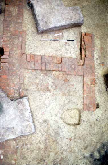 Figure 20. Closeup of central fireplace.
21
the hearth would not be burned. The lack of burnt subsoil under the southern hearth suggests its floor was raised, indicating that the adjoining room had a wooden floor from the start.
Figure 20. Closeup of central fireplace.
21
the hearth would not be burned. The lack of burnt subsoil under the southern hearth suggests its floor was raised, indicating that the adjoining room had a wooden floor from the start.
The dwelling clearly had glass windows installed sometime during its life. Distribution maps of window leads and flat glass show heavy concentrations of both in its interior and the vicinity immediately surrounding it. One window lead recovered from around the house was dated 1635, suggesting that the structure had glass windows from its inception.
Other architectural details are harder to discern. No indication of the original roofing material has survived, and later expansion of the building destroyed any possible evidence of a second exterior entranceway on the structure's east side.
Structure B
(The Kitchen)
Around the same time he was building his house, Kemp oversaw construction of a large brick outbuilding facing Structure A (Figure 21). Evidence indicates that this entire building was also executed entirely in brick, and that it served the plantation as its kitchen, servant's quarters, and storage facility.
The Kemp-period portion of the building was a roughly square room measuring 24 feet east-west and 20 feet north-south (Figure 22). The bricks of the 1640s walls were poorly made with the dry course consisting of laid brick bats — four and five
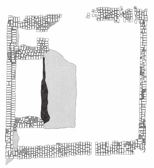 Figure 21. Kitchen/quarter.
22
Figure 21. Kitchen/quarter.
22
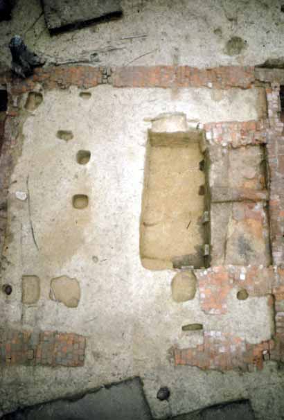 Figure 22. Kemp's portion of the kitchen.
across. About eighteen rows of the center room's dry course are missing on the north wall and two rows are missing on the south wall. These gaps appear to be damage from nineteenth-century plowing rather than indications of structural features.
Figure 22. Kemp's portion of the kitchen.
across. About eighteen rows of the center room's dry course are missing on the north wall and two rows are missing on the south wall. These gaps appear to be damage from nineteenth-century plowing rather than indications of structural features.
Structure B's foundation bricks strongly resemble those of Structure A's Kemp period component, and its four-brickbat-wide dry course footers are also the same. Window leads dating to the 1630s confirm an early construction date for the building. Only the dry courses of the room's east and west walls remain, with the remaining two walls being destroyed by later renovations.
The remains of the north wall's C-shaped hearth are of the same construction as the rest of the center room (Figure 23). The hearth measured 10 feet wide by 3 feet deep, indicating it was used for both cooking and heating. Only the east and west spurs survive, since the original rear wall was also lost in later renovation. The size of the hearth, especially in comparison with Structure A's two smaller hearths, strongly suggest that Structure B was built as a separate kitchen.
Inside the hearth were a series of clay floors, one laid on top of the next. The earliest of these probably dates to the Kemp period, with the lowest five contexts predating 1665. This configuration, along with the presence of root cellars and the shelving related post holes, suggest that the kitchen had a dirt floor for its entire life.
A number of often-replaced large root cellars were located around Structure B's fireplace, the earliest of which appear to date to the Kemp period (for detailed discussion of root cellars, see Chapter 5). Unfortunately almost all of this root cellar was
23
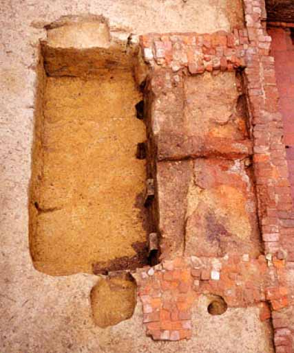 Figure 23. Closeup of fireplace.
destroyed by later replacements. While no datable artifacts were found in the small portion that did survive, the absence of architectural material relating to the large-scale renovations suggests that this feature was abandoned and filled in before 1665.
Figure 23. Closeup of fireplace.
destroyed by later replacements. While no datable artifacts were found in the small portion that did survive, the absence of architectural material relating to the large-scale renovations suggests that this feature was abandoned and filled in before 1665.
Another feature found in the kitchen was a baking oven that incorporated the east spur of the hearth into its design (Figure 24). The brick oven had a square base measuring 5 by 5 feet, and while this is the only portion of the feature that has survived, several unglazed floor tiles were found in and around the structure that may have been part of the actual baking surface.
Located in front (south) of the baking oven were three overlapping pits, the earliest of which dates to the Kemp period. Small and circular in shape, and with vertical sides and a flat bottom, this pit measured 14 inches across and 10 inches deep. The pit was filled with charcoal, brick and mortar and was likely abandoned and refilled sometime after 1650, since it was subsequently disturbed by two later pits that date to the Thomas Ludwell period before 1665.
Kiln
Ground-penetrating radar identified a brick kiln south of the kitchen. Because it was located on a portion of the site owned by a commercial builder, we were able to excavate only a single one-meter test unit in this feature. The unit exposed what appears to be the rear wall of the kiln. The firebox cut 5 feet into subsoil and consisted of unlined clay walls. The fill contained three layers: (1) a clay layer containing brick fragments which sealed (2) a brick rubble and ash layer which in turn sealed (3) an ash and burned oyster shell layer which sat on the firebox floor.
24 Figure 24. Closeup of bake oven.
Once the fill was removed a single channel was identified. Two baked clay arch footings bracket and a flue measuring approximately 2 feet in width. The blackened outline of the flue was also evident on the rear wall.
The kiln appears to have been a semipermanent, rectangular updraft-type kiln. The use of arch footings made of clay is atypical. Normally, both benches and arches are built of unfired bricks that are fired as part of the kiln's load.
The layer of burned oyster shell covering the floor suggest that lime was also prepared in the kiln. Although mortar is an integral part of masonry construction, such evidence of mortar manufacturing is rare.
Three kilns of similar design have been identified within a five-mile radius of Rich Neck. Two of these are located on Jamestown Island, while the other was discovered at Bruton Heights in Williamsburg (Figure 25). All three date to the seventeenth century (Muraca and Hellier 1992: 58).
Several clay quarry pits associated with the kiln were the earliest features found at Rich Neck. All but one of these pits were relatively small, very deep, and irregularly shaped. These smaller pits were immediately backfilled by their seventeenth-century diggers with the same material removed during excavation, contained very few artifacts, and where stratigraphic relationships could be determined, were always the earliest feature. One good example was located underneath the bounding ditch south of the dwelling (Figure 26). Measuring 6.5 feet by 8 feet, this roughly rectangular feature extended 20 inches below the bounding ditch that surrounded the site. Filled with a single episode of redeposited subsoil, this feature and the other small pits seem to be failed attempts at finding suitable clay for brickmaking.
25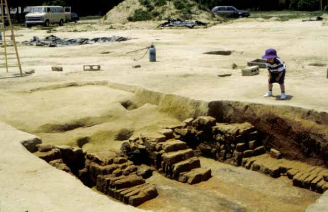 Figure 25. John Page's brick kiln.
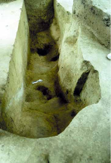 Figure 26. Half-excavated small clay quarry pit.
Just east of the dwelling was the "successful" quarry pit (Figure 27). This large oval-shaped feature, measured 58 feet north-south and 50 feet east-west, and was dug over 5 feet below grade. Its relatively flat bottom contained rows of linear channels about 3 feet wide where clay had been shoveled out across the bottom of the pit (Figure 28).
The clay in the bottom was extremely sandy. Bricks made out of this material would have been of poor quality, similar to those found in the Kemp portions of the dwelling and kitchen. The clay may have received its initial processing while still inside the pit, since the impression of where a barrel had once stood was pressed into the floor of the southernmost channel.
Once the need for clay was satisfied, the pit took on a new role. Left uncovered, the lowest portions of its channels silted in completely and then additional silt accumulated over the entire bottom, in some areas to over 20 inches deep. These layers contained very few artifacts, suggesting that the pit was purposefully kept free of waste material. It also appears that the pit was at least seasonally wet, with the accumulated water serving to quench livestock.
Enclosures
Three enclosures were built during the Kemp period. The first encompassed the area between the dwelling and the kitchen. Using the foundation walls of both buildings in conjunction with five sections of fence, this enclosure formed a six-sided polygon that measured roughly 50 feet by 50 feet. One gate was located in the southwest corner of the enclosure.
The trenches were shallow, linear features generally measuring 6 to 8 inches in depth and 6 to 10 inches in width (Figure 29). Some had rectangular or circular
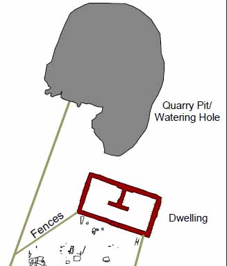 Figure 27. Successful quarry pit.
27
Figure 27. Successful quarry pit.
27
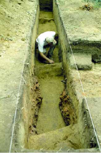 Figure 28. First trench through quarry pit.
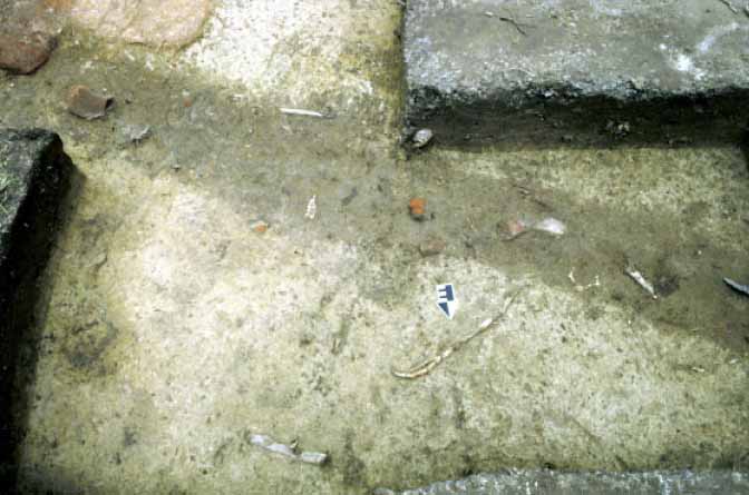 Figure 29. Slot fence connecting kitchen to main E-W fence.
28
features associated with them, which were invariably located on one side of the trench, slightly cutting it, and extending deeper into the subsoil. No molds were apparent in any of the circular features, and they appear to be the remains of support posts for the pale fences.
Figure 29. Slot fence connecting kitchen to main E-W fence.
28
features associated with them, which were invariably located on one side of the trench, slightly cutting it, and extending deeper into the subsoil. No molds were apparent in any of the circular features, and they appear to be the remains of support posts for the pale fences.
The area inside the polygon contained fewer artifacts than any other space located adjacent to one of the brick structures. This is odd, because the area contained the main entranceways into both structures. Although seventeenth-century trash disposal practices usually employed tossing garbage out of all exterior entranceways, this area appears to have been purposely kept clean.
Scattered throughout the inside this enclosure were several plant related features, including bush holes, tree holes, and possible furrows (Figure 30). Although some postdate the Kemp period, it is possible that this area was employed as a garden as early as the 1640s (Figure 31). Soil chemistry and phytolith analysis shows that areas near the dwelling were cool, partially shaded, and damp, while closer to the kitchen it was shady and dry. The area just east of the kitchen also contained phytoliths from corn husks or cobs (Sullivan 1999).
The second enclosure was a bounding ditch that surrounded the structures, of which several large sections were exposed and excavated (Figure 32). No evidence was found on east side of the site, but this area was disturbed by road construction. Preservation varied from one area of the site to another. The least well preserved section was located at the northern end, where only the very bottom of the ditch survived road construction. The measurements from the best preserved section of the ditch indicate that it was originally over 5 feet wide and over 3 feet deep. The northern side was filled fairly early and replaced with a slot fence. The portions of the ditch south and east of the structure survived much longer, but they were also eventually replaced by slot fences. The southern section and possibly others were redug at least
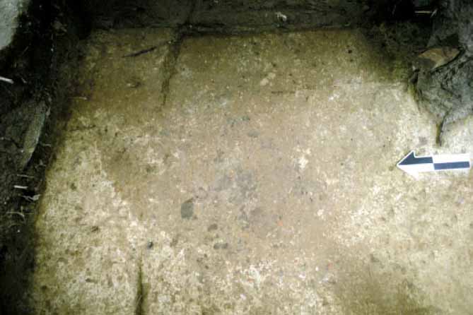 Figure 30. Plan view of planting hole.
29
Figure 30. Plan view of planting hole.
29
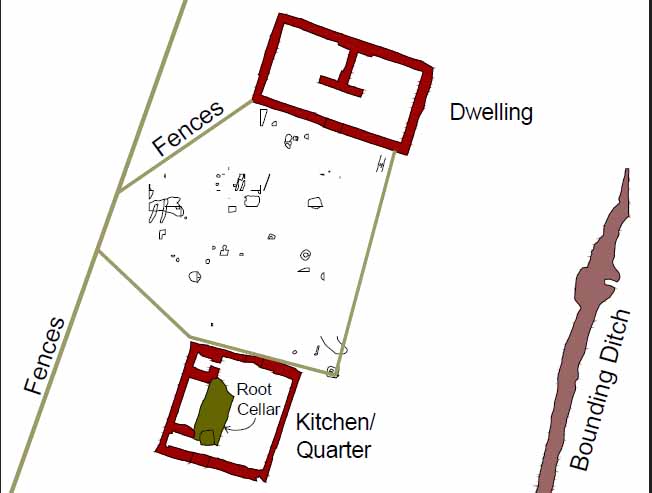 Figure 31. Plan of garden area.
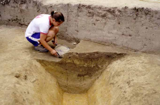 Figure 32. Excavated section of bounding ditch.
30
once, presumably after the original channel had collapsed or silted in. Several depositional layers filled the ditch, consisting most often of silt.
Figure 32. Excavated section of bounding ditch.
30
once, presumably after the original channel had collapsed or silted in. Several depositional layers filled the ditch, consisting most often of silt.
At its western end the ditch tapered to a point creating a large opening designed to control admittance into the homelot complex. It is not clear how large this opening was because its opposite side was destroyed by road construction, but a gate was probably employed to limit access.
A similar feature was uncovered at Martin's Hundred's Site A, the 1630s administrative center. An oval-shaped ditch surrounding eight acres of the site was uncovered in 1970. The only break or entranceway was located to the south of the complex. This ditch was 3 feet wide and cut 1 foot deep into subsoil. There were no signs of a palisade associated with this ditch (Klingelhofer n.d.).
The last enclosure was a long fence that divided the site east-west (Figure 33). Running parallel to the brick structures and located between them and the northern section of the bounding ditch, this fence eventually replaced the northern half of the ditch, and became the most important fence on the site. Its center section was initially employed as one of the six sides of the polygon that bounded the space between the two main structures, and it was replaced and altered several times to meet the changing needs of the plantation.
 Figure 33. Detail of main E-W fence.
Refuse Middens
Trash disposal during the Kemp period clustered in several spots. The largest area was located west of the kitchen and contained oyster shells, faunal remains, nails, ceramics and glass. Imported pipestems with 9 64ths bore diameters were found in this trash pit, as was a bottle seal displaying the initials "RK" (Figures 34 and 35).
Distribution maps of the site's earliest pipestems also show that three sides of the dwelling house received trash in the 1640s. A small concentration was located on the southern perimeter of the site near the bounding ditch. In order to get to this area, occupants would have had to walk through the enclosed area between the structures in order to dispose of their trash. A small ravine finger also attracted trash in the 1640s. Located just north of the dwelling, this area contained some early artifacts. Early pipestems and Kemp bottle seals were also found in the large quarry pit east of the house.
Discussion
While Kemp's Rich Neck was in many ways a typical early colonial tobacco plantation, there were several aspects of the site that were unusual. These anomalies include the layout of the complex, the building materials used for the dwelling and kitchen, and the existence and design of the garden/clean space.
Structures Made of Brick
Around 1639, Richard Kemp had built one of the finest houses in Jamestown. As the first all-brick house in Virginia, this house set the construction standards for Jamestown as well as its hinterland. Upon Kemp's return to Virginia, he constructed a strikingly similar house at Rich Neck, which was possibly the first all brick structure constructed in the colony outside of Jamestown. The kitchen appears to be the first all brick dependency built in Virginia.
Together these buildings established a benchmark for later Middle Plantation construction. By the 1670s, brick
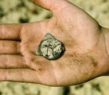 Figure 34. Richard Kemp bottle seal.
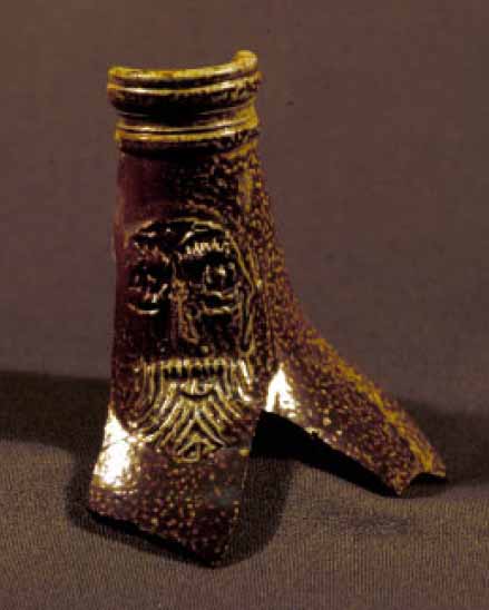 Figure 35. Bartmann bottle.
32
structures in Middle Plantation included John Page's house (Figure 36) and up to seven outbuildings, the dwelling house under Nassau Street (a 44 feet by 20 feet foundation and cellar) (Figure 37), and (by 1683) the Bruton Parish church (66 feet by 29 feet). Other brick structures that date to the Middle Plantation period included the College of William & Mary's Wren Building, and two structures (the larger of which measured 28 feet by 20 feet) located behind the George Wythe House. A group of related Middle Plantation structures were also found under the eighteenth-century Public Hospital. The dwelling house measured 37 feet by 23 feet and contained a brick lined cellar, water table bricks, window glass, and delft fireplace tiles with hand-painted nautical scenes. The support structure contained a brick-lined full basement, casement windows, and brick paving. On the western side of town, a cluster of five brick foundations have been uncovered near Bassett Hall. At least two of these structures seem related to the Brays, a prominent Middle Plantation family.
Figure 35. Bartmann bottle.
32
structures in Middle Plantation included John Page's house (Figure 36) and up to seven outbuildings, the dwelling house under Nassau Street (a 44 feet by 20 feet foundation and cellar) (Figure 37), and (by 1683) the Bruton Parish church (66 feet by 29 feet). Other brick structures that date to the Middle Plantation period included the College of William & Mary's Wren Building, and two structures (the larger of which measured 28 feet by 20 feet) located behind the George Wythe House. A group of related Middle Plantation structures were also found under the eighteenth-century Public Hospital. The dwelling house measured 37 feet by 23 feet and contained a brick lined cellar, water table bricks, window glass, and delft fireplace tiles with hand-painted nautical scenes. The support structure contained a brick-lined full basement, casement windows, and brick paving. On the western side of town, a cluster of five brick foundations have been uncovered near Bassett Hall. At least two of these structures seem related to the Brays, a prominent Middle Plantation family.
While all this brick construction was taking place at Middle Plantation, no brick structures were built at the neighboring settlements of Kingsmill or Martin's Hundred. Perhaps Kemp's brick structures served as an impetus for later Middle Plantation settlers.
Protection
At the time of its establishment Rich Neck was located near the Anglo-Powhatan frontier. Although it was part of Middle Plantation, Rich Neck was outside the area "protected" by the palisade of 1634 (see Metz et al. 1998 for a good description of this feature). Tension between the local Indian population and the English settlers was
 Figure 36. John Page house.
33
Figure 36. John Page house.
33
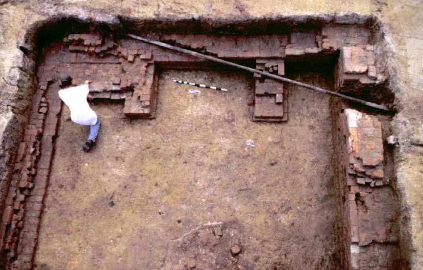 Figure 37. Nassau Street cellar.
again approaching a high point as Rich Neck was being established. At the same time, a civil war was brewing in England between Parliament and King Charles I. Dangerous times call for precautions, and in Virginia this often meant wooden palisades. Palisaded settlements in the area include Nansemond Fort, Flowerdew Hundred, and the earliest sites at Martin's Hundred (Sites C and H).
Figure 37. Nassau Street cellar.
again approaching a high point as Rich Neck was being established. At the same time, a civil war was brewing in England between Parliament and King Charles I. Dangerous times call for precautions, and in Virginia this often meant wooden palisades. Palisaded settlements in the area include Nansemond Fort, Flowerdew Hundred, and the earliest sites at Martin's Hundred (Sites C and H).
Rich Neck was not surrounded by an archetypal palisade, but by a large ditch similar to one found at the administrative center at Martin's Hundred. While not a classic defensive barrier, this ditch may have acted as more as a psychological barrier that served to comfort inhabitants rather than actually protect them. The ditch probably also served to keep livestock out of the compound. The opening on the west side would have regulated foot and horse traffic, forcing visitors and inhabitants to pass by the kitchen before arriving at Kemp's dwelling house.
Landscape Design
The landscape of the early years at Rich Neck was characterized by concentric zones of modification (Figure 38). On the edge was the "wilderness" fashioned by the Powhatans, the least modified portion of the Rich Neck landscape. Large dark forests of mature trees containing little undergrowth would have dominated this area (Silver 1990). Some active and abandoned tobacco fields with girdled trees were probably located directly adjacent to the forest, giving the landscape a rough and tumble look. Closer to the dwelling were the two acres ringed by the bounding ditch, and bisecting the oval created by the ditch was a major fence that ran east-west. The area between the ditch and the fence was ideal for growing food crops and for establishing the plantation's orchard, and the area south of the dwelling would also have been well suited for planting food crops and fruit trees. The ditch would have prevented the
34
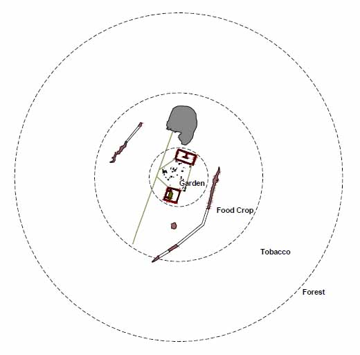 Figure 38. Landscape zones.
livestock ranging in the nearby forest from destroying these crops. The center section of the primary fence was also used as the northern boundary of the innermost landscape zone, the area which was located between the two structures. Once visitors passed through the fences that enclosed this space behind, they entered a landscape that must have stood in stark contrast to the Virginia wilderness. Kemp used a combination of fences and structures to completely encircle this area. On one side was the front of the dwelling house with its main entryway located in the center. The front of the structure featured its most formal brick and glass facade. Directly across and facing Kemp's dwelling was the kitchen/quarter. This building's size and construction material made it equally impressive. It also featured glass windows, and had an entryway directly across from the dwelling's. Connecting the two main structures and completely enclosing the area between them were several paling fences, which defined a clean space that was purposefully kept clear of refuse even during the early days of Rich Neck. Distribution of 9/64th inch and 8 64th inch pipe stem bore diameters (the earliest pipes found on the site) show very few fragments were discarded in this area. In a very non-seventeenth-century fashion, trash was carried out to the edges of the enclosed area before disposal. Located throughout this clean space were features that once contained purposefully planted flora, including bush holes, tree holes and linear furrows. While they cannot be definitively tied to the Kemp period, these features appear be the remains of an early garden.
Figure 38. Landscape zones.
livestock ranging in the nearby forest from destroying these crops. The center section of the primary fence was also used as the northern boundary of the innermost landscape zone, the area which was located between the two structures. Once visitors passed through the fences that enclosed this space behind, they entered a landscape that must have stood in stark contrast to the Virginia wilderness. Kemp used a combination of fences and structures to completely encircle this area. On one side was the front of the dwelling house with its main entryway located in the center. The front of the structure featured its most formal brick and glass facade. Directly across and facing Kemp's dwelling was the kitchen/quarter. This building's size and construction material made it equally impressive. It also featured glass windows, and had an entryway directly across from the dwelling's. Connecting the two main structures and completely enclosing the area between them were several paling fences, which defined a clean space that was purposefully kept clear of refuse even during the early days of Rich Neck. Distribution of 9/64th inch and 8 64th inch pipe stem bore diameters (the earliest pipes found on the site) show very few fragments were discarded in this area. In a very non-seventeenth-century fashion, trash was carried out to the edges of the enclosed area before disposal. Located throughout this clean space were features that once contained purposefully planted flora, including bush holes, tree holes and linear furrows. While they cannot be definitively tied to the Kemp period, these features appear be the remains of an early garden.
Further evidence of a garden comes in the form of flower pot fragments (Figure 39). While difficult to accurately date, these coarse earthenware vessels were frequently used to transport plants from England and other colonies such as Bermuda, and for potting and displaying plants. Fifteen flower pot fragments were found scattered around the area between the two structures.
Most early colonial gardens were kitchen related, except for a few ornamental plantings in the gardens of Virginia's wealthiest elites. Designed to be accessed from within the house with little or even no access from outside, this practice is reminiscent of English medieval gardens (Meatyard 2000). Documentary evidence of existence of early colonial gardens comes from Menefie's Littletown plantation with its orchard, roses, rosemary, sage, and thyme. Rich Neck provides an illustration of how these landscape features were possibly incorporated into a plantation's design.
Rich Neck's spatial layout was also unusual. While almost all the plantation seats at Middle Plantation employ at least two structures in their design, they were laid out in a different configuration. The Middle Plantation norm consisted of a multipurpose dwelling house and a support structure that operated as a kitchen and also housed servants. Kemp's plantation is no exception, but the spatial relationship of Rich Neck's structures is different from those of other Middle Plantation sites. The Page site is an excellent example of the typical Middle Plantation layout (Figure 40). Visitors to the house would have encountered the dwelling first, with the kitchen/quarter purposely
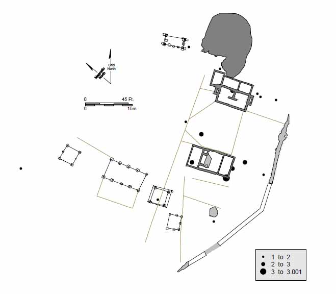 Figure 39. Distribution of flower pot fragments.
36
Figure 39. Distribution of flower pot fragments.
36
 Figure 40. Overview of Page site.
located behind it and off to one side. Other Middle Plantation planters located their support structures directly behind their dwelling house (Muraca 1995). Unfortunately, archaeological investigation into these properties is incomplete when compared to Rich Neck. More extensive excavations around these early structures might have uncovered details of how these sites were situated in the landscape.
Figure 40. Overview of Page site.
located behind it and off to one side. Other Middle Plantation planters located their support structures directly behind their dwelling house (Muraca 1995). Unfortunately, archaeological investigation into these properties is incomplete when compared to Rich Neck. More extensive excavations around these early structures might have uncovered details of how these sites were situated in the landscape.
Chapter 4.
Sir Thomas and Lady Elizabeth Lunsford Ownership (1650-1653)
Elizabeth Wormeley Kemp ignored her husband's last request that she sell Rich Neck and return to England. Instead she stayed in Virginia and remarried, taking Sir Thomas Lunsford as her next husband (Figure 41). Lunsford was a colorful Royalist émigré who arrived in Virginia in 1649.
Born in Sussex in 1611, Thomas Lunsford developed a reputation as a troublemaker with a temper quite early in life. In June 1632, he was charged with killing a deer belonging to his kinsman Sir Thomas Pelham, and was fined a total of 1750 pounds. Later that year, Lunsford stopped Pelham and fired two shots at him but missed. Lunsford was committed to Newgate for this offense. He escaped in 1634 and made his way to France, where he joined the French Army. He spent the next six years in France and the Low Countries, gaining such a reputation for courage and skill that he was promoted to the command of a regiment of foot. He returned to England in 1639, and immediately petitioned the King for a pardon which was granted. By 1640, Lunsford was holding a command in the Bishops' Wars, where he distinguished himself at the Battle of Newburn (Sainbury 1907).
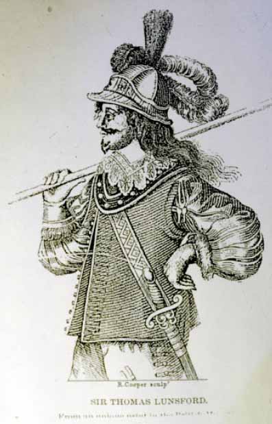 Figure 41. Lunsford portrait. From Thomas-Stanford 1910.
As a supporter of Charles I, Lunsford was made Lieutenant of the Tower of London, replacing Sir William Balfour, a staunch supporter of Parliament. Opposition to the appointment came from both the Common Council and the House of Commons. The political pressure proved too much, and Lunsford was removed from his post after serving just five days, but was compensated two days later by being knighted (Sainsbury 1907). The day after his removal, he and several supporters were involved in an incident where several apprentices who were supporters of Parliament were wounded. It may have been this incident that gave rise to his reputation as a child killer.
During the Civil Wars, Lunsford and his regiment were vilified by the Roundheads in poems, songs, and illustrations. They frequently referred to Lunsford's regiment as "Lunsford's Babyeaters" and verses such as this were typical:
Make children, with your tones, to run for't
As bad as bloody-bones or Lunsford (Sainsbury 1907)
A pictorial attack featured Lunsford in full armor standing in front of a burning church, a woman being attacked, and a corpse being dragged by the hair. Under this graphic was the verse:
I'll help to kill and pillage and destroy
All the opposers of the Prelacy,
My fortunes are growne small, my friends are less,
I'll venture therefore life to have redress;
By picking, stealing, or by cutting throats
Although my practice cross the kingdom's votes (Sainsbury 1907)
Instead of refuting the charge that Lunsford was a child killer, Cavalier poetry actually embellished this image of him. Some historians interpret this elaboration as ridicule of the parliamentarian vilification (Sainsbury 1907), but it may have also been a way to embellish his reputation as a combatant. The most noteworthy Cavalier tract is The Royal Feast, written by Sir Francis Wortley while a prisoner of the Tower of London. He and several other Royalist prisoners were feasting on two bucks sent by the King, and in celebration wrote this song, which has one stanza about Thomas Lunsford, a fellow detainee:
Gallant Sir Thomas, bold and stout
(Brave Lunsford), children eateth;
But he takes care, where he easts one,
There he a hundred getteth;
The Royalist sympathizer Cleveland picked up on the theme of Lunsford as baby killer:
The post that came from Banbury,
Riding on a blue rocket,
He swore he saw when Lunsford fell,
A child's arm in his pocket (Cleveland in Sainsbury 1907)
Another Cavalier verse characterized Lunsford this way: 39
From Fielding and From Vavasour,
Both ill-affected men;
From Lunsford eke dilver us,
That eateth up children. (Mackay 1997)
Yet another:
They feat the giblets of his train,
Even his dog, that four-legged cavalier;
He that devours the scraps that Lunsford makes,
Whose picture feeds upon a child in steaks (Cleveland in Sainsbury 1907)
Parliament declared Lunsford a traitor in January 1641, and issued a warrant for his arrest. Although arrested and brought before the House of Commons, he was soon free again. By June of that year, Lunsford was again soldiering in the service of the King, building his reputation as a courageous and skilled tactician. He fought at the battle of Edgehill, and was captured and imprisoned until May 1644. Lunsford was released in a prisoner exchange and continued to fight for the Royalist cause. He was captured again at the battle of Hereford in 1645, and in 1649, after the beheading of the King, sold all and emigrated to Virginia.
Upon his arrival in the colony, Governor Berkeley, fearing invasion from parliamentary troops, appointed Lunsford lieutenant-general of militia and a member of Council. He was forced to retire his office after the colony surrendered to Parliament (Merz 1976). In 1650, Lunsford patented a 3,432-acre plantation on the Rappahannock River called Portobago (Nugent 1979). His second wife, Catherine, followed him to Virginia, but died soon after her arrival (William & Mary Quarterly [hereafter WMQ] (2) (3):197). Remarriages were swift in seventeenth-century Virginia, where a high mortality rate joined with the notion that matrimony was an efficient way to either build or strengthen political and economic alliances. With both their spouses having recently died, and being social peers, Lunsford and Elizabeth Wormley Kemp married. Because Lunsford had been knighted, his bride acquired the title of Lady Lunsford.
Sir Thomas Lunsford was dead by 1653, and Elizabeth Kemp Lunsford took over running her affairs. Throughout her widowhood, Lady Elizabeth held her own among the landed gentry of the day. That Governor William Berkeley and councilor George Ludlow stood as witness for her in land deals testifies to her connections (Nugent 1979:229). After Lunsford's death, "Dame Elizabeth" continued to buy and sell land until she married Major-General Robert Smith of Lancaster in 1659 (Nugent 1979: 229,288). Smith also had extensive land holdings on the Northern Neck, and was a high-ranking official in the provincial government (Nugent 1979:228, 235). In 1675, he accompanied Thomas Ludwell and Colonel Francis Morgan to England as agents of the colony.
Documentary evidence indicates that even though Elizabeth and Thomas Lunsford owned property elsewhere, they lived at Rich Neck throughout the years of their marriage. The inscription of the marble slab quoted above states that Lunsford was 40 buried near the other owners of Rich Neck, so it is logical to assume that he was living on the property at the time of his death.
Archaeological Features
Thomas Lunsford short tenure at Rich Neck resulted in only a few changes to the site. The two brick structures were unaltered, as were most of the fencing or other large landscape features (Figure 42). However, a new post-in-ground structure was added.
Structure G
(Agricultural Shed)
One of the more unusual architectural discoveries at Rich Neck was the uncovering of a seven-post structure located to the west of the kitchen (Figure 43). This building—Structure G—sat on roughly the same orientation as the site's other two buildings, and its south wall aligned with the north wall of Structure B.
Three aspects of Structure G are noteworthy. The first was its location near the site's other post structures in a low-use part of the site. Structure G predates these
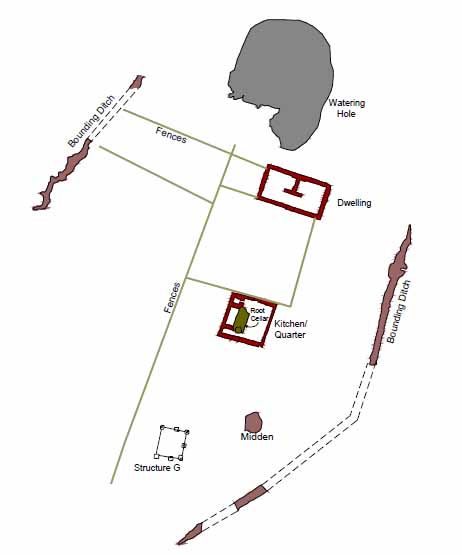 Figure 42. Lunsford's Rich Neck.
41
Figure 42. Lunsford's Rich Neck.
41
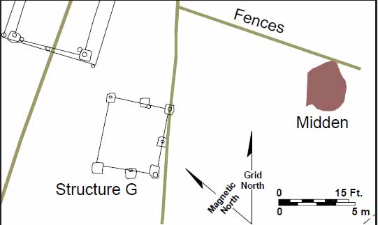 Figure 43. Overview of Structure G.
structures and appears to have been razed by the time they were built. The second was that it was composed of an uneven number of posts. The third was that the postholes had been dug to markedly different depths at the time of the building's construction. Thorough examination of the surrounding area revealed no other features in the structure's immediate vicinity, excluding the possibility that these different-depth postholes were unrelated.
Figure 43. Overview of Structure G.
structures and appears to have been razed by the time they were built. The second was that it was composed of an uneven number of posts. The third was that the postholes had been dug to markedly different depths at the time of the building's construction. Thorough examination of the surrounding area revealed no other features in the structure's immediate vicinity, excluding the possibility that these different-depth postholes were unrelated.
The three deepest postholes were along Structure G's south wall (Figure 44). Each of these postholes contained identifiable molds, and two—68AV-75 and 68AV-255—were cut by a later fence trench. That this trench cuts two of Structure G's postholes indicated that the structure was no longer standing at the time the fence was built around 1665.
Posthole 68AV-75 was Structure G's southeast corner and measured 28 by 24 inches and bottomed at a depth of 22 inches. The round post mold for this hole (68AV-192) measured 10 inches across and became visible only after the removal fence related trench. The next posthole to the west was 68AV-255, which measured 26 by 23 inches and had a flat bottom at 28 inches deep. Postmold 68AV-257 sat in the center of the posthole, was oval shaped, and measured 9 by 8 inches. Posthole 68AV-189 represented Structure G's southwestern corner. This posthole measured 35 by 26 inches and excavators found its flat bottom at 18 inches below the subsoil level. Its mold was round in plan measuring 12 inches across. These three features were the deepest of the seven and possessed the most pronounced postmolds.
Postholes 68AV-251 and 68AV-270 sat in line to the north of postholes 68AV-75 and 68AV-189. The easternmost, 68AV-251, measured 23 by 22 inches. Its flat bottom was found at 12 inches. The westernmost posthole 68AV-270 measured 25 by 28 inches. Excavators located its flat bottom at 5 inches. This posthole also contained a circular postmold 68AV-288, measuring 7 inches across and 5 inches deep. The shallowest of the seven postholes were the two that constituted Structure G's north wall. Posthole 68AV-215 measured 30 by 32 inches with a
42
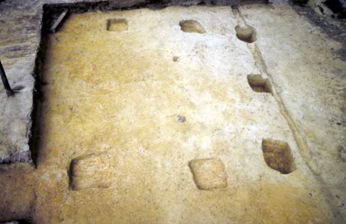 Figure 44. Structure G.
flat bottom at a depth of 6 inches. Posthole 68AV-217 measured 24 inches square had a flat bottom at 6 inches in depth. No mold was detected.
Figure 44. Structure G.
flat bottom at a depth of 6 inches. Posthole 68AV-217 measured 24 inches square had a flat bottom at 6 inches in depth. No mold was detected.
Structure G dates to the Lunsford period of occupation. The presence of wine bottle glass in its postholes indicates it was built after 1650. The number of features cutting this structure and the absence of artifacts dating from the 1660s indicates this structure did not last long. Several artifacts associated with the renovation of the kitchen were found in one of the molds, suggesting the structure was demolished around 1665.
Its unusual construction style suggests that this structure was a lean-to. The southern line of holes represent the tallest portion of the structure, with the northern line representing the lowest portion. This structure was clearly not used as a dwelling and probably served some agricultural function.
Enclosures
Lunsford added at least four new fences, and removed two others. The dismantled fences were part of the six-sided polygon that outlined the garden space between the dwelling and the kitchen. The sections of fence oriented on a diagonal were torn down and replaced with fence sections that were on the same orientation as the structures. Instead of a six- sided polygon this new arrangement formed a square.
Lunsford also began to subdivide the area north of the dwelling. A fence was built connecting the back of the dwelling and the northernmost portion of the bounding ditch. To the west, a second fence connected the bounding ditch and the east-west fence that bisected the site just north of the structures. This construction created two new enclosed areas on the site, both north of the dwelling. Between the dwelling and the east-west fence was one enclosure. Just north of this area was a second enclosed area between the bounding ditch and the east-west fence.
Discussion
The transformation of the garden boundaries from an asymmetrical six-sided polygon to a square possibly reflected Lunsford's ideals about how garden space should be presented. He made this change with minimal effort, retaining two of the original fences and the structures as part of the perimeter. While creating a more simple shape, Lunsford did not make the space more symmetrical. The garden space still extending out past the structures to the north without a corresponding increase to the south. Even so, the outcome must have been pleasing, for the new shape was maintained until the plantation was eventually abandoned.
Artifact, elemental, and phytolith analysis suggest different functions for the two new subdivisions created by Lunsford (Figure 45). The small enclosed area just north of the dwelling contained high concentrations of calcium and phosphorous, very few artifacts, and maize and panicoid grass phytoliths (Figures 46, 47, and 48). Panicoid grasses flourish in warm, wet, open areas and are likely to occur in areas with few trees and where the natural vegetation is disturbed (Sullivan 1999). This data suggests that this small enclosed space was used to pen animals. Its small size suggests a specialized use and its location on the north side of the dwelling diminishes the possibility that this area was used as a kitchen garden. The presence of corn may infer animal feeding and the presence of high amounts of phosphorous in combination with high amounts of calcium suggests the presence of animal waste. The larger enclosed area contained smaller amounts of calcium, phosphorous, and potassium. Phytoliths that dominate this area are arboreal/dicots with high starch grain counts, suggesting an extensive root system that had decayed in place (Sullivan 1999:120). One sample from this area contained a high percentage of sedge phytoliths, suggesting a damp or wet microhabitat. When combined, this data suggests that the area was either forested or an orchard. Lunsford's use of fences to demarcate and protect this area indicates that an orchard is a better interpretation than simply a forested area.
44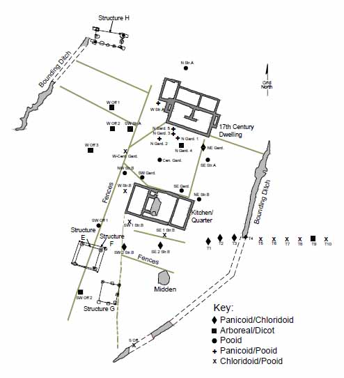 Figure 45. Distribution of phytoliths.
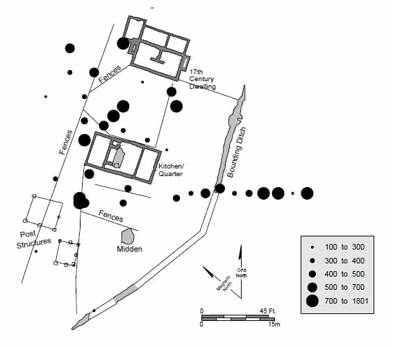 Figure 46. Distribution of phosphorous.
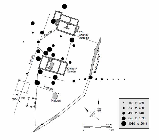 Figure 47. Distribution of calcium.
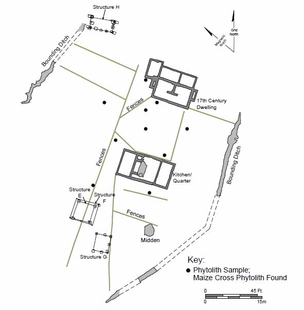 Figure 48. Distribution of maize phytoliths.
Chapter 5.
Thomas Ludwell Ownership (1665-1677)
Shortly after Thomas Lunsford's death, Elizabeth Kemp Lunsford moved from Rich Neck to a Lancaster County plantation near her Wormeley kin. With little need for an aging plantation near Jamestown, in spring 1665 Elizabeth and her third husband, Robert Smith, repaid a £1000 debt they owed Thomas Ludwell by signing Rich Neck over to him, ending the estate's dozen years of relative absentee ownership (Figure 49).
Thomas Ludwell, Rich Neck's new owner, was born in Somerset County, England in 1628. He arrived in Virginia in 1646 as a headright of his cousin Sir William Berkeley (Nugent 1979:165). By 1648, he had already patented a tract of land in James City County (Nugent 1979:429). In 1661, he became the Secretary of the Colony, four years before he acquired Rich Neck. Two years later, he claimed land in Henrico County for the passage of a number of immigrants, including his younger brother Philip and two persons of African origin (Nugent 1979:429).
Like Menefie, Kemp, and Lunsford, the Ludwells became two of the most prominent and powerful men in the colony. But Thomas and Philip were also different from
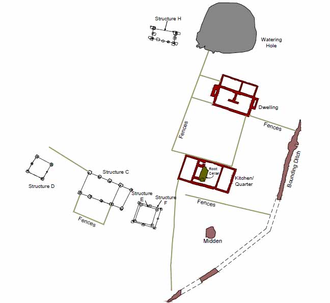 Figure 49. Thomas Ludwell's Rich Neck.
48
their predecessors. They were part of a group of elites who would dominate the colony in the second half of the century. This new group of leading planters, immigrants who arrived from England in the 1650s and 1660s, would make up a self-conscious ruling class (Bailyn 1993). They amassed enormous tracts of land, built larger and more substantial homes, and dominated the politics of Virginia through the increasingly powerful Council of State. Their sons would take positions on the Council as if by hereditary right.
Figure 49. Thomas Ludwell's Rich Neck.
48
their predecessors. They were part of a group of elites who would dominate the colony in the second half of the century. This new group of leading planters, immigrants who arrived from England in the 1650s and 1660s, would make up a self-conscious ruling class (Bailyn 1993). They amassed enormous tracts of land, built larger and more substantial homes, and dominated the politics of Virginia through the increasingly powerful Council of State. Their sons would take positions on the Council as if by hereditary right.
Thomas and Philip Ludwell fit into this emerging colonial aristocracy well. The Ludwell brothers were, in their time, arguably the most powerful men in the colony short of the governor, and Philip periodically even rivaled the chief executive in influence over the General Assembly. Philip's son would carry on this tradition of government service into the next generation.
As secretary, Thomas Ludwell was second only to Berkeley in prestige and power. He collected payment in tobacco for issuing land patents, marriage licenses, and for every other official document that was within the purview of his office (Morgan 1975). Like his predecessor Richard Kemp, Ludwell's position as Secretary entitled him to sit on the Council, an office that provided him with additional fees (Morgan 1975). In addition to his Rich Neck land, Ludwell patented several other tracts, the bulk of which was in New Kent and Westmoreland counties. Like other prominent men of his time, Ludwell appears to have been a land speculator, amassing huge holdings in the frontier areas of Virginia for the use of future Ludwells or to sell for profit. He purchased 1,432 acres in Westmoreland County in 1670 and added 2,994 acres to his holding in Henrico in 1671. His largest acquisitions were in New Kent where, in 1673, with two partners he patented 20,000 acres (Nugent 1977:84, 92, 130, 132).
In 1675, Thomas Ludwell and Giles Bland became involved in a heated argument while at Ludwell's home. Ultimately Bland nailed Ludwell's glove to the door of the Statehouse as part of the initial stage of a duel. The duel never took place; instead Bland was arrested and fined. A year later, Ludwell and Bland would find themselves on opposite sides of Bacon's Rebellion, with Bland a key leader in the rebel cause and Thomas and Philip Ludwell as strong supporters of Berkeley.
While Philip actually led troops into battle against Bacon's supporters, Thomas was in England when the rebellion broke out, and took advantage of his presence there to urge the King to quell the uprising by rushing troops to the colony. After Jamestown was burned in 1676, the records of the General Court and Secretary's office were moved to Rich Neck for safekeeping. Thomas lost livestock and personal property at the hands of Bacon's men, but it is unclear if this took place at Rich Neck or at one of his other properties. Giles Bland eventually lost his life during the rebellion when he was captured and hanged by Berkeley.
In 1676, Thomas became ill; he died the next year. He willed the majority of his estate, including Rich Neck, to Philip.
Archaeological Features
Rich Neck underwent tremendous renovations after Thomas Ludwell acquired the property. He refurbished the dwelling and kitchen, added several post-in-ground structures 49 to the homelot, reshaped the landscape, and added architectural embellishments that were impractical in 1640.
Structure A
(Thomas Ludwell's Dwelling)
Ludwell added two rooms to the rear of the dwelling that ran its entire length (Figures 50 and 51). The foundation for this addition was one-and-a-half brick courses wide and abutted the east wall of the original foundation. After the house was abandoned, workers removed portions of the east and north walls of the addition, leaving only a robber's trench. The addition was 10 feet deep and increased the overall dimension of the house to 35 by 30 feet. The east room measured 9.5 by 12.5 feet with a foundation that intruded subsoil over 18 inches (seven courses), suggesting the superstructure was made entirely of brick. The foundation for the addition's west room (9.5 by 20 feet) was shallower, suggesting a light foundation and wood-framed walls (Figures 52 and 53).
Exterior end chimneys built on the north and south walls replaced the central chimney, which was dismantled (Figure 54). These foundations were 2½ courses wide, with the hearths measuring 13 feet long by 2.5 feet deep and abutting the original portion of the house. Like the interior fireplace, they were offset behind the peak of the roof, one brick course shy of being flush with the back wall. The builder's trench for the chimneys was relatively shallow, measuring 9 inches deep and cutting the builder's trench for the original house. Tin-enameled fireplace tiles that decorated the south hearth featured paintings of children playing games, including archery and golf (Figure 55).
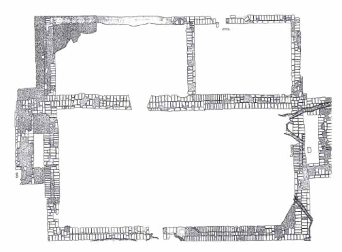 Figure 50. Dwelling during Thomas Ludwell period.
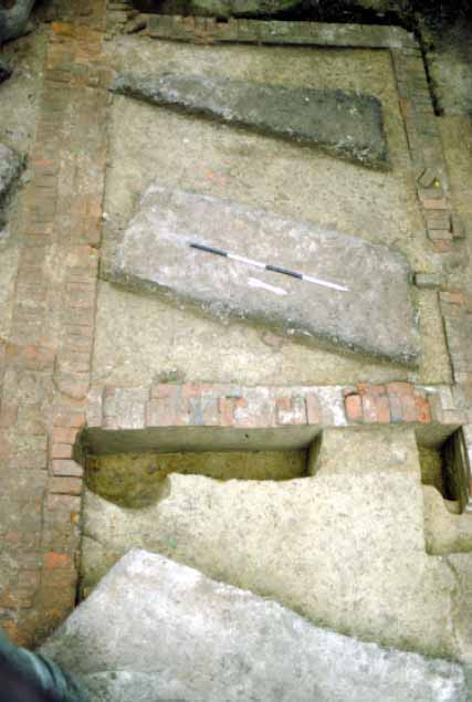 Figure 51. Rear room additions.
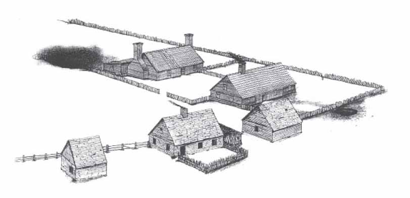 Figure 52. Reconstruction of Rich Neck, circa 1670. Drawing by David Brown.
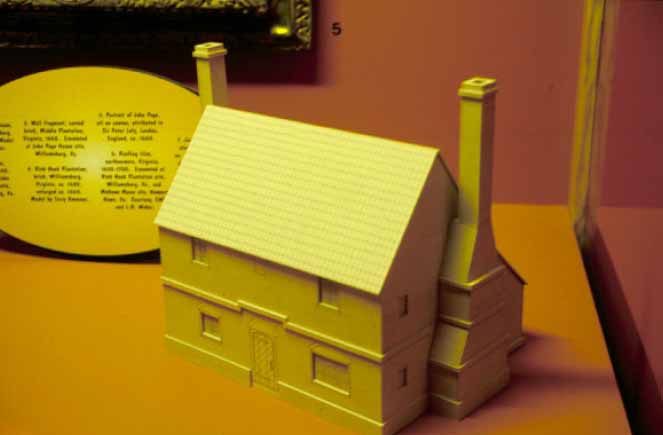 Figure 53. Model of Rich Neck dwelling as a two-story structure. Designed by Cary Carson.
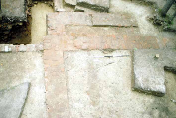 Figure 54. Closeup of exterior chimney.
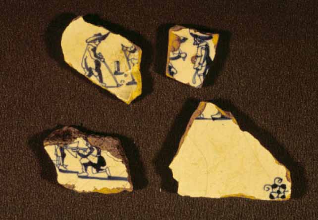 Figure 55. Fireplace tiles featuring children playing games.
The brick used during this renovation appears to have been made off site. All of the quarry pits found were associated with the earliest occupation of the site. The renovation bricks are also of much better quality than the 1640s bricks, further suggesting they came from a different source.
In the hall, a large, deep root cellar or buttery was installed in front of the hearth. It measured 7.5 by 4 feet and was 3 feet deep. Casks of wine or beer were stored in butteries. This feature survived until the house was dismantled, at which time it was filled in a single episode.
A new roof, made of earthenware pan tiles, covered the entire structure (Figure 56). Held in place with shell mortar, thousands of broken tile fragments clustered around the dwelling.
Kitchen/Quarter/Workspace
In its day, Ludwell's kitchen was perhaps the largest brick outbuilding in Virginia. Located opposite of the plantation's residence, it also underwent renovations when Ludwell took control of the property. Like the dwelling house, these additions augmented the size and capacity of the building's original plan. Watertable bricks and very large quantities of brick rubble in and around the structure indicate that this building was executed entirely in brick, serving the plantation as a kitchen, quarter for servants, and as a combination workspace and storage facility. In addition to these functions, Ludwell reserved one portion of the structure for his own personal use.
The renovation of the kitchen included two new sections, with the entire structure being covered by a new pan tile roof (Figures 57 and 58). The final plan measured 36 feet north-south by 24 feet east-west, and was divided into three components. Flanking the roughly square center room were matching rectangular additions. Both of these additions measured 13 feet north-south and 24 feet east-west and contained full cellars
53
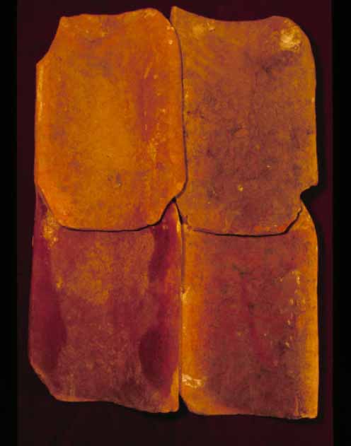 Figure 56. Pantile roof.
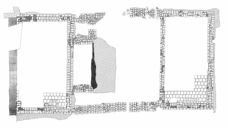 Figure 57. Kitchen/quarter/work building.
54
Figure 57. Kitchen/quarter/work building.
54
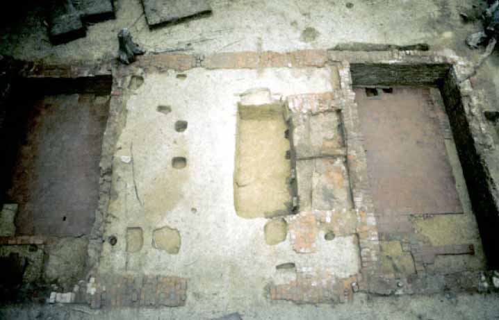 Figure 58. Overall of kitchen.
filled with bricks, tiles, mortar, and plaster from the demolition of the building. The bricks of the additions were well-fired and laid in a brick-and-a-half-wide English bond. Watertable bricks were found associated with both cellars. The foundations of the two additions were complete rectangles. Later, robbers removed most of the building's foundations.
Figure 58. Overall of kitchen.
filled with bricks, tiles, mortar, and plaster from the demolition of the building. The bricks of the additions were well-fired and laid in a brick-and-a-half-wide English bond. Watertable bricks were found associated with both cellars. The foundations of the two additions were complete rectangles. Later, robbers removed most of the building's foundations.
A fairly uniform builder's trench surrounded the foundations of both additions, except for the exterior of the north wall of the north cellar, which featured a trench that ran the length of the wall truncating the top of the builder's trench. This feature, filled with deep-subsoil clay collected from somewhere off site, averaged 21 inches in width and 15 inches deep. The placement and characteristics of this clay packed feature suggests an attempt to prevent water from penetrating through the addition's subterranean wall. Under the clay fill was a 5-inch-wide builder's trench which matched the size, color, and artifact content of the foundation's other builder's trenches.
Key elements of the central room survived from the Kemp period including part of the hearth and the bake oven foundation (Figure 59). The dry courses of only the room's east and west walls remain, the north and south walls having been replaced by the internal walls of the cellar additions. This suggests that the subterranean courses of the cellar additions were under-dug and built beneath the center room's existing north and south wall. This technique, which would have destroyed the footers of the center room's north and south walls, including the original rear wall of the hearth, appears to be the same as that used in constructing Structure A's cellar addition (see Chapter 6).
In addition to a brick hearth along its north wall, the central room contained a number of large root cellars directly in front of the hearth and the remains of three small pits located in front of the bake oven.
Two of the small pits appear to be replacements for an earlier feature that dated to the Kemp period. The larger of the two measured 20 inches across and 10 inches
55
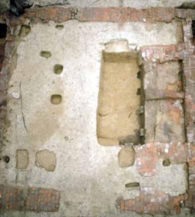 Figure 59. Kitchen center room.
deep. Filled with sandy loam that contained a concentration of brick bats, this hole was flat bottomed. The second pit contained large quantities of ash and charcoal. While irregular in plan this feature was much shallower than its companion holes, measuring only 1 inch deep. These small pits seem to be small root cellars, purposefully created to preserve root vegetables and other perishables (Figure 60).
Figure 59. Kitchen center room.
deep. Filled with sandy loam that contained a concentration of brick bats, this hole was flat bottomed. The second pit contained large quantities of ash and charcoal. While irregular in plan this feature was much shallower than its companion holes, measuring only 1 inch deep. These small pits seem to be small root cellars, purposefully created to preserve root vegetables and other perishables (Figure 60).
In front of the center room's substantial brick fireplace were the remains of three large root cellars. Because they virtually occupy the same space, only a small portion of the earliest cellar has survived, with a bit more of the second cellar remaining, and with all of the latest cellar surviving intact.
It is impossible to determine the original size of the earliest cellar. Only the easternmost portion of which has survived. Measuring 20 by 7 inches, this cellar had vertical sides and a flat bottom, and contained two layers of fill. The earliest layer mirrored the shape of what's left of the root cellar. This yellowish brown sandy clay loam contained charcoal, brick bits, and mortar. Over this layer was a yellowish brown sandy loam with charcoal flecking. The absence of renovation related artifacts suggests that this root cellar dated to either the Kemp or Lunsford period.
At some point the first root cellar failed and Root Cellar 2 replaced it. The remnants of this feature measured 9 feet E-W, 18 inches N-S, and extended over 3 feet into subsoil. Because of the placement of a later and larger root cellar, it is impossible to determine the original north-south measurement. The root cellar contained three layers, the earliest of which formed while the pit was still in use. This layer was less than an inch thick, was made up of a dark yellowish brown sandy loam, and contained large quantities of eggshell fragments and straight pins. On top of the layer was a collapsed portion of the northern subsoil wall which consisted of sterile yellow clay that covered only a small portion of the cellar. The rest of the cellar was filled during a single event with friable brown sandy clay containing significant quantities of charcoal and brick flecks. Artifacts recovered from this layer, include ceramics, pipestems, straight pins, lead, roofing and floor tiles. The cellar's abandonment and filling took place during Philip Ludwell's ownership based on a TPQ date of 1675.
56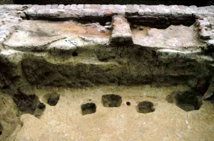 Figure 60. Closeup of root cellar showing postholes.
Inside the root cellar were a series of related small postholes measuring roughly 12 inches square, and containing rectangular molds that measured 4 inches by 3 inches. The three postholes appear to be the remains of supports for a wooden cover for the cellar. Since the cellar sat directly before an active hearth, the posts may have acted to keep the cover from direct contact with fire. Located in the northeast corner, the northwest corner and at a point halfway in-between, the posts may have also braced the northern wall of the root cellar, preventing its collapse.
Sealing the root cellar were a series of thin clay hearth floors. Backfilling the cellar allowed for the expansion of the cooking area, because the construction of a replacement cellar took place 12 inches farther to the south.
The most recent root cellar measured 11 by 5½ feet and was not quite 3 feet deep. At the bottom was a layer that formed while the cellar was still in operation. This thin (1-2 inch thick) dark yellowish brown sandy loam covered two-thirds of the cellar floor but contained only a few artifacts, none of which were datable.
Several features cut this layer, including a group of five postholes with molds. The last cellar cut into both of its predecessors, resulting in edges made of backfilled soil instead of dense subsoil clay on two sides. This suggests that both sides were more likely to experience collapse than sides that cut subsoil. In order to prevent collapse, Ludwell had a series of posts installed, four along the northern wall and a fifth on the eastern wall (Figure 61).
The four posts were placed in a line. The westernmost posthole, which measured 12 by 9 inches, had vertical sides and a flat bottom. The posthole contained a dark yellowish-brown sandy loam fill with charcoal flecking throughout. Its square postmold measured 5 inches across. Two feet to the east was the next posthole, which measured 10 by 9 inches and was V-shaped in profile. Filled with the same soil as was the
57
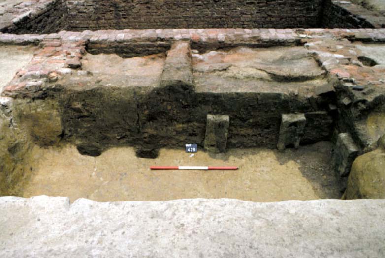 Figure 61. Detail of root cellar showing reinforcing postholes.
westernmost hole, this posthole had a square mold that measured 4 inches across. Thirty-two inches to the east was the next posthole and mold. It measured 9 by 7 inches and had vertical sides and a flat bottom. It too contained very similar fill as its companion holes, and had a square mold measuring 6 inches across. The last posthole was located 17 inches to the west. It measured 8 by 10 inches, and had an angled, V-shaped bottom with a square mold of 4 inches. Along the eastern wall of the root cellar was an additional postmold that served the same function as the four posts located on the north wall. This 4-inch-square mold was located 32 inches south of the northern wall.
Figure 61. Detail of root cellar showing reinforcing postholes.
westernmost hole, this posthole had a square mold that measured 4 inches across. Thirty-two inches to the east was the next posthole and mold. It measured 9 by 7 inches and had vertical sides and a flat bottom. It too contained very similar fill as its companion holes, and had a square mold measuring 6 inches across. The last posthole was located 17 inches to the west. It measured 8 by 10 inches, and had an angled, V-shaped bottom with a square mold of 4 inches. Along the eastern wall of the root cellar was an additional postmold that served the same function as the four posts located on the north wall. This 4-inch-square mold was located 32 inches south of the northern wall.
There were two notches cut into the southern wall of the root cellar approximately three feet apart (Figure 62). Both contained the root cellar's earliest fill layer, and they may represent where the cellar was subdivided perhaps using boards.
Four layers were used to fill the root cellar when it either failed or was not longer needed. The earliest was an irregular sandy clay that contained pockets of clay, sand, silt, and mortar. Found only in the southeast corner, this 10-inch-thick layer was sealed by a second fill layer that was also only found in this corner. This second layer was redeposited subsoil that contained charcoal, mortar and brick fragments, and a pocket of plaster. On top of was a third layer that covered the entire root cellar. This layer was thickest (16 inches) on the south side and tapered to almost nothing on the north side, consisted of dark yellowish brown sandy loam, and contained charcoal flecks and a number of straight pins. The final fill layer also covered the entire cellar and was a dark yellowish brown sandy loam with subsoil clay mottling. This layer contained the heaviest concentration of artifacts, including ceramics, pipestems, and straight pins. The root cellar's fill contains leaded table glass indicating abandonment and filling sometime after 1670s. One of the postholes (68AT-430) contained a window lead impressed with the date [1]686, suggesting the posts were not original, but used to
58
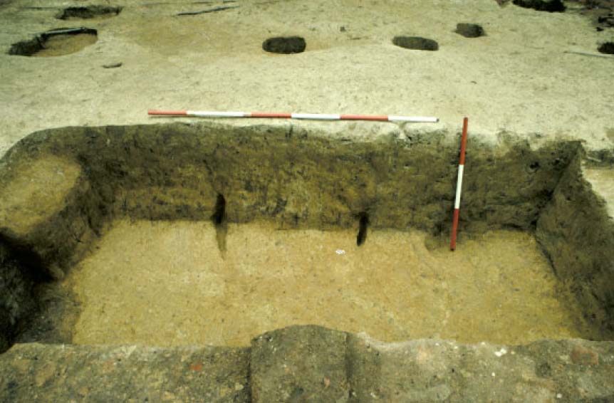 Figure 62. Detail of root cellar notches.
reinforce existing walls. That these posts cut through a layer that formed while the feature was still in use confirms that the posts were added after the construction of the cellar. The absence of large quantities of architectural material indicates the filling of the cellar took place before the building was abandoned and torn down. Why the root cellar was no longer needed toward the very end of the building's life remains unknown.
Figure 62. Detail of root cellar notches.
reinforce existing walls. That these posts cut through a layer that formed while the feature was still in use confirms that the posts were added after the construction of the cellar. The absence of large quantities of architectural material indicates the filling of the cellar took place before the building was abandoned and torn down. Why the root cellar was no longer needed toward the very end of the building's life remains unknown.
The kitchen's fireplace was atypical in several ways (Figure 63). Normally, fireplace floors either don't survive or are just areas where heat has turned the subsoil pink. The dwelling, for example, has both missing and burned pink subsoil hearth floors. On the other hand, the kitchen's hearth floors are made up of a jumble of features and layers cutting and stacked one on top of another (Figure 64). The fireplace measured 10 by 3.5 feet, and contained over 20 contexts, including several thin clay layers that covered different parts of the fireplace floor. Ten of these layers/features postdate the construction of the cellar additions, indicating that they date to the Thomas or Philip Ludwell periods. The rest have no relationship with the builder's trench and are hard to assign to a time period.
Listed in order from most recent to earliest, the features/layers are as follows. The latest fireplace floor (68AT-591) was a sandy clay fill approximately 4 inches thick. Under it was a gray sandy clay (68AT-592) that ranged in thickness from 1 to 2 inches. Layer 3 (68AT-593) was a dark yellow brown sandy clay located near 68AT-592. Layer 4 (68AT-594) was a yellow brown clay that measured 4 inches in thickness and sealed four different contexts. Layer 5 (68AT-595) was located only on the eastern half of the fireplace. This small lens of plastic brown clay measured about the same thickness as layer 4. Layer 6 (68AT-596) was a dark yellow brown clay, irregular
59
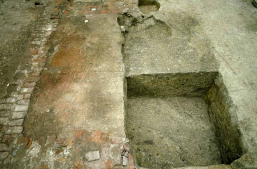 Figure 63. Fireplace floor before excavation.
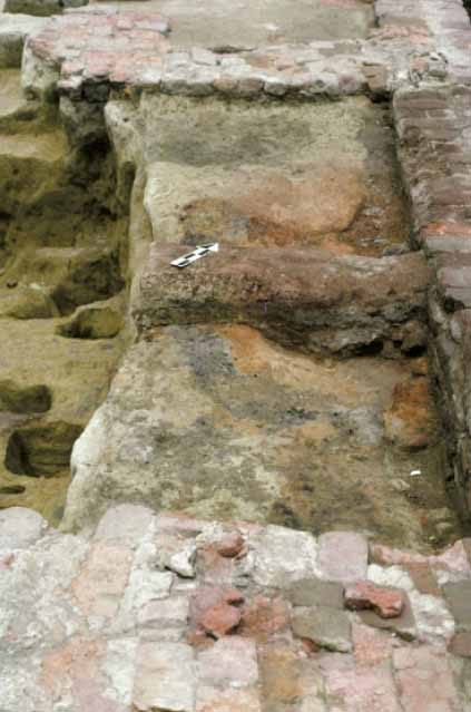 Figure 64. Fireplace floor during excavation.
60
in shape and appeared related to layers 4 and 5. Layer 7 (68AT-597) contained charcoal, ranged in depth from 1 to 4 inches and was made up of a dark yellowish brown clay. Layer 8 (68AT-598) was a small lens located in the center of the fireplace that was made up of dark yellowish brown sandy clay. Layer 9 (68AT-599) was located in the back of the hearth, ranged in thickness from 1 to 3 inches, and was made up of an ashy gray clay. Layer 10 (68AT-600) was a very large feature located in the center of the fireplace. It was irregular in plan and profile and was primarily filled with a reddish yellow clay. This layer contained glazed floor tiles like those found in the cellars of the additions. Layer 11 (68AT-604) was a small lens of brownish yellow clay situated in the northeast corner of the fireplace.
Figure 64. Fireplace floor during excavation.
60
in shape and appeared related to layers 4 and 5. Layer 7 (68AT-597) contained charcoal, ranged in depth from 1 to 4 inches and was made up of a dark yellowish brown clay. Layer 8 (68AT-598) was a small lens located in the center of the fireplace that was made up of dark yellowish brown sandy clay. Layer 9 (68AT-599) was located in the back of the hearth, ranged in thickness from 1 to 3 inches, and was made up of an ashy gray clay. Layer 10 (68AT-600) was a very large feature located in the center of the fireplace. It was irregular in plan and profile and was primarily filled with a reddish yellow clay. This layer contained glazed floor tiles like those found in the cellars of the additions. Layer 11 (68AT-604) was a small lens of brownish yellow clay situated in the northeast corner of the fireplace.
Layer 12 was the builder's trench for the north addition's cellar. It contained fragments of the new cellar floor tiles and roofing tiles. Layer 13 (68AT-606) covered the western half of the fireplace. This yellowish-red clay contained several ash pockets. Layer 15 (68AT-609) was a square feature filled with reddish-yellow clay. Layer 16 (68AT-610) was a linear feature in the northwest quadrant of the fireplace. This gray clay contained charcoal and ash. Layer 17 (68AT-611) extended over much of the hearth. This dark gray clay contained charcoal and ash. Layer 18 (68AT-612) was a small lens of dark brown clay with black soot. Layer 19 (68AT-613) was also a rectangular feature with a dark brown sandy loam. Layer 20 formed the lowest layer for most of the western portion of the fireplace. Irregular in plan as well as profile, this feature was filled with a brown silty sand containing charcoal and brick bits.
In the eastern side of the fireplace a posthole was discovered underneath all the layers (Figure 65). Filled with dark reddish gray sandy loam this hole measured 26 by 28 inches and contained a square postmold which measured 14 by 8 inches. The posthole and mold cut 6 inches into the subsoil under the hearth. This post appears to have been used to hold up a cooking pot or utensils or perhaps supported a spit.
This plethora of layers and features suggests specialized cooking took place in the kitchen. Several features were actually pits dug into the floor for some particular cooking task. When the pit was no longer needed worker filled it in and covered it with a new clay floor. Most cooking activities took place in the center of the fireplace, with more specialized cooking projects located on the extremities of the hearth floor.
Several small postholes were also found in the central room, located mostly along the west wall and in the south half of the room. The postholes ranged in size from 16 by 16 inches to 16 by 24 inches. The molds were circular and ranged from 6 to 8 inches across. These holes date to the Thomas Ludwell period and are possibly part of a shelving system.
The Additions
Excavations of the brick-lined cellars associated with the additions took place over two summers. Fill in the cellars was divided into quadrants and removed in 25 percent portions.
South Cellar
The rubble in the south cellar was divided into five layers with some degree of variation and occasional pockets. Although the depth of individual layers varied somewhat
61
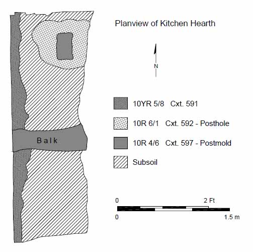 Figure 65. Fireplace floor after excavation.
between quadrants, the overall depth of fill was 44 inches. The top layer consisted of a combination of sandy loam soils and small brick, mortar, and pantile rubble. This layer ranged in depth from 3 to 15 inches, and covered a second layer made up of brick and mortar rubble that ranged from 6 to 17 inches in thickness. A third layer consisting primarily of pantiles, bricks and mortar varied in depth from 6 to 12 inches.
Figure 65. Fireplace floor after excavation.
between quadrants, the overall depth of fill was 44 inches. The top layer consisted of a combination of sandy loam soils and small brick, mortar, and pantile rubble. This layer ranged in depth from 3 to 15 inches, and covered a second layer made up of brick and mortar rubble that ranged from 6 to 17 inches in thickness. A third layer consisting primarily of pantiles, bricks and mortar varied in depth from 6 to 12 inches.
A final layer of brick fragments and mortar ranged in depth from 8 to 38 inches, and covered several shallow layers (ranging from ¼ to 2 inches in depth) of moist organic soils in all but the northeast quadrant, where 43 inches of clean rubble sealed the cellar floor. The organic layers contained large amounts of window glass and covered tile flooring that extended across most of the cellar's floor. The moistness of these last layers may be largely due to the tiles' inability to absorb descending rain water.
The south cellar's tile flooring was laid from wall to wall, with closer courses of half tiles filling out the pattern around the edges (Figure 66). However, the pattern was disrupted on the cellar's east side. Tiles extended to a one-course-thick line of bevelled bricks set in the floor and sitting ¼ inch higher than the tile level and four feet west of the east wall. These bricks measured 9 inches in width and extended 5½ feet from the south wall into the center of the cellar. A single line of bricks laid end-to-end extended to the east wall from the end of the beveled bricks. These bricks appeared to form the base of walls that blocked in the cellar's southeast corner to form a room measuring 48 by 62 inches. This room was only partially tiled and much of it was covered with the same rubble as found in the cellar fill's lowest debris level. Its tiles were laid in an east-west pattern contrasting with the north-south orientation of the rest of the tiles and its east wall showed evidence of plastering.
An area measuring 6 by 5 feet in the northeastern corner of the cellar showed no evidence of having been tiled. This area's subsoil showed evidence of bricks pressed into its surface.
62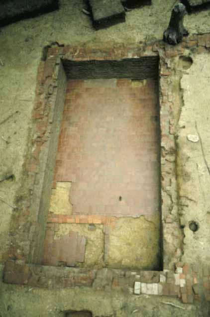 Figure 66. South cellar overview.
On the opposite side of the cellar were two architectural features similar to those found at the neighboring contemporary house of John Page. Located at the west end of the Ludwell kitchen's south cellar was a sump designed to drain water out of the cellar during flooding (Figure 67). The sump was of simple design. Its designer removed tiles from the floor and dug a hole in the subsoil. Water found its way (or was swept) into the hole and slowly drained out. Rubble filled the sump, suggesting it was still functioning when the structure was torn down. Just south of the sump was a pad one brick wide and seven bricks long. The Page cellar had a similar brick pad located in the tile floor of its stair tower. The function of these pads remains unknown.
North Cellar
The fill in the north cellar strongly resembled that in the south cellar in both content and stratigraphy. Small-rubble filled layers, measuring between 6 and 7 inches yielded onto brick and mortar layers which were between 23 and 28 inches deep. These in turn covered pantile and brick fragments measuring between 16 and 32 inches deep. Several layers containing less rubble followed. These last layers covered the tile floor.
The north cellar also contained three rooms, the largest of which had glazed floor tiles as in the south cellar (Figure 68). But unlike the south cellar, the north cellar's tiles did not employ closer courses or stretch from wall-to-wall. Instead, destruction
63
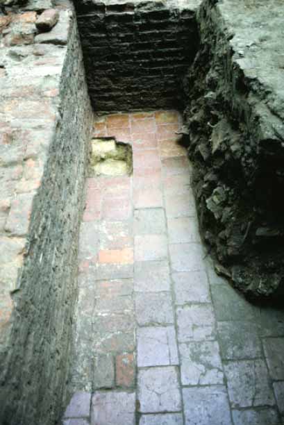 Figure 67. Closeup of sump and brick pad.
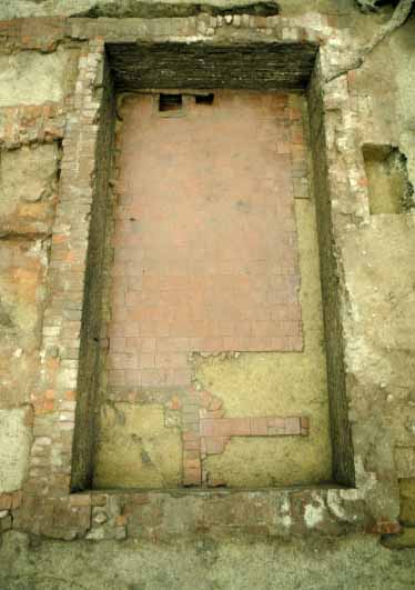 Figure 68. North cellar overview.
64
debris and organic soil filled a gap between the tiles and the wall along the cellar's south wall. On the north side a partially robbed line of bricks laid side-to-side spanned a distance of 12 inches between the tiles' ¼-tile closer courses and the bottom of the wall. Areas of destruction soils covered the spaces seemingly left open by the robbed bricks.
Figure 68. North cellar overview.
64
debris and organic soil filled a gap between the tiles and the wall along the cellar's south wall. On the north side a partially robbed line of bricks laid side-to-side spanned a distance of 12 inches between the tiles' ¼-tile closer courses and the bottom of the wall. Areas of destruction soils covered the spaces seemingly left open by the robbed bricks.
Both of Structure B's cellar additions were constructed as single subterranean units built alongside the then-still-standing center room kitchen. The cellars' destruction fill, with its high numbers of bricks, brick bats, and pantiles, offer ample evidence that the structure was built of brick and that it was covered with a pantile roof. The cellars' relatively low artifact counts, lack of mortared-together bricks, and lack of scorching also suggest that the structure was intentionally disassembled at a time after it was in day-to-day use. Furthermore, the orderly episodic quality of the destruction fill and the lack of trash or soil accumulation strata within the rubble suggests that the cellars' destruction occurred over a short period of time, thus limiting the opportunity for the accumulation of natural or cultural sediments. Tightly datable artifacts such as dated window leads and wine bottles located within all strata of the fill place the destruction after the late 1680s.
The untiled areas in the cellars appears to be landings for stair cases. The subsoil height matches the height of the tiles indicates that no tiles were ever set in this area, while a small 4 by 6 inch hole in the tiles south of the untiled landing may be where a staircase's newel post stood. Holes in the brick foundation show where stairs would have been tied in (Figure 69).
On the western end of the north cellar were two holes located side by side in the tile floor (Figure 70). These holes abutted the west cellar wall and unlike the sump in the south cellar they had their sides and floors lined with bricks and tiles. The southern hole was the larger of the two, measuring 12 inches square (interior measurements). Its sides were bricked (4 bricks deep) and its floor was made of glazed tile fragments. The edges of this hole showed no signs of wear.
The northern cavity was lined with bricks, with its interior measuring 12 by 8 inches. It was the same depth as the southern hole, but had a brick rather than a tile floor. The uppermost bricks lining this hole shown signs of wear on the east and south sides.
Connecting these holes was a small channel one brick in depth located on the western edge of the two holes. The channel narrows from 3 inches to 1 inch as it neared the smaller northern pit.
Both holes were filled with the same rubble as the cellar, suggesting they were in use at the time of the building's destruction. These features are clearly related to each other. Their proximity to each other and the channel that connects them support this contention. They seem to be part of a workstation where liquids underwent processing. The evidence indicates that a liquid was poured into the larger pit and left to separate, with the lighter portion then floating down the channel into the smaller pit, where it could be scooped out. It is still unclear what liquid was being processed. An example of a similar process is extracting cream from milk. In order to produce cream, milk is poured into a container and left alone to separate. Once it separates, the cream
65
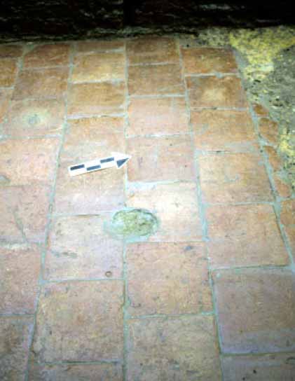 Figure 69. Closeup of where stairs tied into floor.
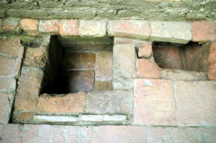 Figure 70. Two work pits.
66
is scooped off the top. While it is highly unlikely that milk was produced in either of the pits, whatever took place in this part of the cellar employed a similar process.
Figure 70. Two work pits.
66
is scooped off the top. While it is highly unlikely that milk was produced in either of the pits, whatever took place in this part of the cellar employed a similar process.
Discussion
The central room sported a large hearth, numerous root cellars, storage racks, and a bake oven. These architectural features and their associated artifacts indicate that this room hosted most of the plantation's cooking activities. The north wing sat with its south wall against the central room's hearth, offering constant indirect heat and making this wing an ideal place for servant occupation and workspace. Furthermore, brick work along the hearth's western side suggests it contained the northern wing's primary entry way. The southern wing on the other hand, had neither the indirect heat nor the central room access of its northern twin. Indeed, no evidence of heating in this wing was found, and little conclusive evidence of external entry ways uncovered. The lack of heat and controlled access suggests that this wing possibly served as a storage site where barrels, boxes, or sacks of goods would have been kept. However, there is an anomaly that contradicts this straightforward picture. Both wings have well-laid glazed ceramic tile floors which extend over two thirds of each of their cellar floors, which show marked differences in wear patterns. The northern wing's floor tiles are highly scuffed, chipped and fractured. Some, in fact, show almost no surviving glaze at all. This is clear evidence of heavy daily use. The southern wing's tiles, by contrast, are in excellent condition, and show little damage or wear. This absence of damage undermines the vision of this cold low-access wing serving primarily as a storage or work area for plantation activities.
The lack of floor wear suggests that the southern wing served in a more specialized role than its high-access, heavy-use counterpart. Masters cordoned off some parts of the site for their own tightly controlled access, and it would seem that this drive extended even into buildings commonly used by all of the site's inhabitants. The distribution of three types of artifacts suggests that the southern section of Structure B was one of these areas. Plaster distributions not only confirm the functional differences between north and south wings, but suggest a formality in the southern wing that was missing from its northern counterpart (Figure 71). Status-related curtain rings are found only in two areas of the site—the dwelling house and the southern side of Structure B. Other status-related artifacts, candlesticks and candle-snuffers, also accrued in the southern section of this building (Figure 72). When considered as a whole, the data indicates that unlike the rest of the structure, Rich Neck's master was the principal custodian of the southern third of Structure B.
Historical evidence shows that during Bacon's Rebellion colonial records were moved to Rich Neck for safekeeping. It is possible that the unheated wing of Structure B served as the Ludwells' office and possibly protected Virginia's most important records. Records were frequently stored in unheated structures during the colonial period in order to avoid fire.
Post Structures
Excavators identified five post structures that date to the Thomas Ludwell period. Most of the new post structures sat far from the master's dwelling and constituted a
67
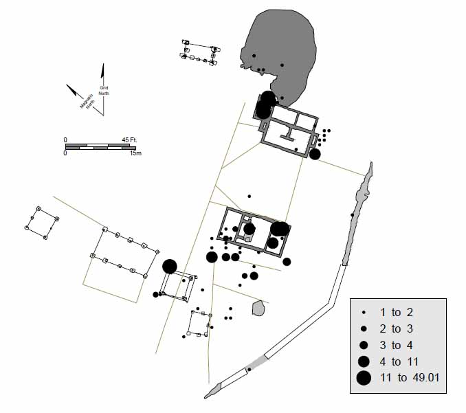 Figure 71. Distribution of plaster.
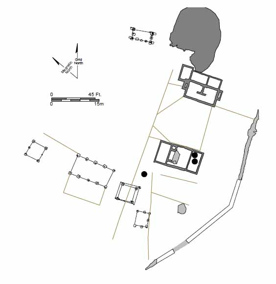 Figure 72. Distribution of curtain rings, candlesticks, and candlesnuffers.
68
distinct quarter area. Archaeological evidence indicates that at least three of these wooden buildings served as the homes of enslaved Africans. A contemporaneous grave of an adolescent African positioned between two of the structures strongly supports this contention.
Figure 72. Distribution of curtain rings, candlesticks, and candlesnuffers.
68
distinct quarter area. Archaeological evidence indicates that at least three of these wooden buildings served as the homes of enslaved Africans. A contemporaneous grave of an adolescent African positioned between two of the structures strongly supports this contention.
Structure C was a post-in-ground building located north of the kitchen (Figure 73). Like Structures A and B, it was oriented on a north-south axis. Eight postholes delineate the 20-foot-wide by 36-foot-long structure (Figure 74). Two additional postholes, slightly smaller in size, indicate that there was also a shed attached to the south end that measured 12 by 20 feet. With the shed attachment, the building had an overall dimension of 20 by 48 feet. Excavation revealed no fireplace remains associated with the building, but traces of a fireplace might easily have been eradicated by plowing or by machine grading. The building did not necessarily employ a brick fireplace foundation; open hearths served by a wood and clay smoke hoods were common in the seventeenth century. This structure did not have glass windows or root cellars.
The postholes that made up Structure C were spaced 8 feet apart on a side, and generally measured 32 by 40 inches across. Posthole depths averaged 12 inches, but this reflects removal by grading of about 4 inches of subsoil. Posthole fill was silty clay that in most cases produced little more than nails. One exception was a posthole that contained fragments of table glass, window glass, and wine bottle glass, as well as a large quantity of architectural debris including tile, nail, and brick fragments. That this and one other posthole contained paving and roofing tile fragments suggesting that Structure C postdated the renovation of Structures A and B sometime after 1665.
All of the postholes had postmolds or post removal holes. Postmolds were square or rectangular in plan, measuring 10 to 12 inches across, and extending the full depth of the posthole. At least three postholes had post removal holes rather than postmolds. Removal holes were rectangular or slightly rounded in plan, were similar in size to postmolds, and also extended to the depth of the postholes. In contrast to the postmolds, the removal holes were characterized by sloping wall profiles and were filled with roofing and paving tile fragments. Those posts probably were rocked and pulled out
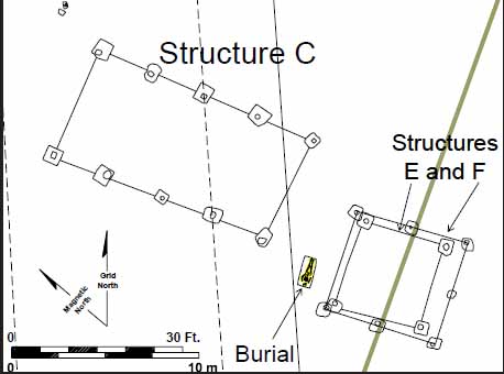 Figure 73. Plan view of Structure C.
69
Figure 73. Plan view of Structure C.
69
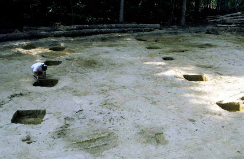 Figure 74. Overall of Structure C.
of their holes with a minimum of digging. The broken tiles that fell into the removal holes suggest that his building was dismantled around the same time as Structures A and B, when debris from those two buildings was scattered across the site sometime near the end of the century.
Figure 74. Overall of Structure C.
of their holes with a minimum of digging. The broken tiles that fell into the removal holes suggest that his building was dismantled around the same time as Structures A and B, when debris from those two buildings was scattered across the site sometime near the end of the century.
The remains of two fences were associated with Structure C. These were shallow, linear features measuring 8 inches deep and 8 to 12 inches wide. The first trench extended from the west side of Structure C at a 90° angle and was about 18 feet long. Excavators retrieved four paving tile fragments from this feature. A second slot trench adjoined the first at a 90° angle and ran for at least 22 feet southward. Logging or brush removal operations that preceded grading had disturbed the area east of this point, and no further traces of the trench were found. The fenceline may have turned back towards the building at this point, or possible continued further before turning. These trenches represent a pale fence that enclosed a square or rectangular area on the west side of Structure C; three sides of that square were formed by the fence, with the wall of the building serving as the fourth side. The fence probably protected a vegetable garden.
Structure C was the plantation's largest slave quarter. It size, physical situation in the midst of the plantation complex, and the artifacts found in association with it all indicate a dwelling rather than an agricultural support building. Archaeological excavation of barns of the seventeenth-century Tidewater show that these structures typically were located away from domestic complexes, off in fields by themselves. Designed to store agricultural implements, fodder, or even crops, barns were situated close to the activities they supported, such as cultivation and animal husbandry. Few if any artifacts were associated with such support buildings. In contrast, Structure C contained large numbers of artifacts, both in the postholes and molds and in the overlying plowzone. Field testing of the plowzone during 1992 produced domestic debris including wine 70 bottle glass, tin-enameled earthenware, and coarsewares. Unfortunately roadway construction destroyed most of the plowzone data, before it could be recovered. Finally, the archaeological record shows that seventeenth-century dwellings often had garden enclosures on their protected side in the same manner as Structure C does. The presence of a burial located just south of the building further suggests that it was a quarter.
Structure D
This post-in-ground building was located directly north of Structure C (Figure 75). It was square in plan, measured 16 by 16 feet, and is represented by four corner postholes and two gable support postholes (Figure 76). The supports were in the center of the north and south walls, indicating that these sides were the gable ends of the building, and therefore, that the structure was oriented north-south along the ridge axis. The presence of gable posts indicates either interrupted sill construction or ground to plate construction; the latter method is more likely given the small dimensions of the gable supports, and it indicates that Structure D had an earthen floor. The building might have employed an open hearth, with either a wood and clay smoke hood or simply an opening in the roof providing ventilation. It might have also been unheated.
This structure lay along the north edge of the road cut, with its southeast posthole in the graded road area. Excavators removed and screened the topsoil overlying the remainder of the structure. Structure D contained four corner posts measuring roughly 27 by 31 inches with postmolds about 8½ inches square. Depths measured about 2 feet below grade. The gable posts were smaller, measuring about one foot square and extending only 2 inches below grade. Excavation of the holes unearthed only one fragment of coarseware suggests that minimum activity occurred in this area before construction of the building.
All other artifacts from this structure came from the postmolds. Among them was a roofing tile fragment, but it did not appear the posts were removed from their mooring
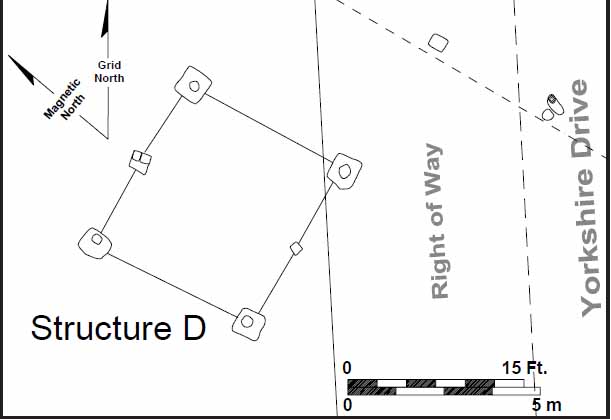 Figure 75. Plan view of Structure D.
71
Figure 75. Plan view of Structure D.
71
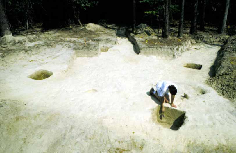 Figure 76. Overall of Structure D.
as was the case with Structure C. Nevertheless, its proximity to, and alignment with Structure C and the rest of the plantation complex indicates that this building probably dates from the Thomas Ludwell period of ownership. The building may have served as a dwelling for slaves or as a service/storage building. It contained no glass windows, no known hearth, and no root cellars. Excavators found some domestic artifacts in the plowzone over the structure, but not enough to definitively determine its function.
Figure 76. Overall of Structure D.
as was the case with Structure C. Nevertheless, its proximity to, and alignment with Structure C and the rest of the plantation complex indicates that this building probably dates from the Thomas Ludwell period of ownership. The building may have served as a dwelling for slaves or as a service/storage building. It contained no glass windows, no known hearth, and no root cellars. Excavators found some domestic artifacts in the plowzone over the structure, but not enough to definitively determine its function.
Structures E and F
Excavators located two overlapping post-built structures in the area to the northwest of Structure B and south of Structure C (Figure 77). Two overlapping post buildings—one four-poster (Structure E) and one six-poster (Structure F)—centered on, and cut, the remains of a slot fence. Only the posts of the structures' northeast corners made contact with each other. The stratigraphic relationship between these postholes indicated that the four-poster predated the six-poster (Figure 78).
Structure E's postholes were rectangular in plan, varied in size from 20 by 24 inches to 32 by 22 inches, and were filled with redeposited subsoil. They had flat sides, flat bottoms, and intruded 12 inches into subsoil. The postmolds for this structure were round and measured 8 inches across.
This building measured 15 by 15 feet, lacked glass in its windows and was torn down sometime after 1665 in order to build its replacement, Structure F. No evidence of a hearth has survived. This building appears to have housed slaves.
A complex of shallow fences cut and overlapped the structure's southeastern posthole—68AT-364. Two of these trenches cut respectively the north and south sides of the posthole. A third trench cut both of the other slot trenches as well as posthole 68AT-364 by curving over these features.
72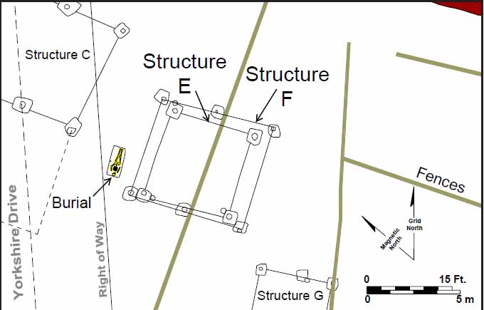 Figure 77. Plan view of Structures E and F.
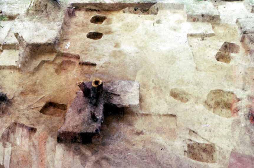 Figure 78. Overall of Structures E and F.
The postholes associated with the six-post structure were mostly rectangular in plan, measuring 26 inches across and between 26 to 34 inches in length. These features had flat sides and a flat bottom, were filled with a yellowish brown redeposited subsoil, and intruded into the subsoil 8 to 16 inches. This 18 by 20 foot structure was built after 1675 and torn down sometime before several fences were installed in this area. The building lacked glass windows or a hearth and appears to have housed slaves. The presence of metal cooking pots suggests that at least some food was cooked in this structure.
The stratigraphic relationships of the features in this area indicate that the site's Kemp/Lunsford period layout saw a fence line running through westward to an undetermined point. This fence was moved to the south when the time the four-post structure went up. Similarly, the six post structure replaced the four-poster and occupied the same space. Both structures are in line with the remains of Structures C and D, suggesting they coexisted for at least a portion of time. Eventually, Rich Neck's occupants tore down Structures E and F and the space they occupied was redefined by the three different fences which cut the remains of Structure E's southeastern posthole. The presence of a curved portion of one slot trench—68AT-366—suggests that the area the post buildings once covered was outside of the area the latest fences intended to enclose.
Structure H
Another post structure was uncovered north of the dwelling, partially on top of where the bounding ditch had previously been located (Figure 79). This structure differed from the site's other wooden buildings in several ways. Its location was unusual in that it was built in a filled ravine and was the only post structure on the eastern half of the site. It's dimensions were odd, measuring 10 by 20 feet. Its post placements were also atypical, with posts located every 5 feet, instead of the more traditional 8 or 10 foot spacing (Figure 80). Finally, its corner posts were replaced not once, but twice, before the structure was torn down. The surviving interior posts (the line of eastern interior posts were completely plowed away) never underwent replacement. Its location in a filled ravine caused the structure to experience water and post-rot problems. Surface runoff and excess water in oversaturated soils would have drained directly into this structure. An excavated trench that was filled with heavy clay likely represents one attempt to keep water out of the building's interior. This trench extended from the southwest corner post to an interior post to the north. This waterproofing may have prevented the interior posts from needing replacement. It also suggests that this structure had a dirt floor. A raised wooden floor would have eliminated the necessity of such a barrier to keep water out.
The original corner posts were roughly square measured about 34 inches across. The holes ranged in depth from 20 to 28 inches. Subsequent repairs completely destroyed the molds for these holes. Workers replaced all four corners at the same time using large rectangular holes that were started on the exterior and worked inward to the failed post. These holes averaged 55 by 22 inches and were the same depth as the original corner postholes. The molds for these holes were circular, measuring 6-8 inches across. Workmen performed the last repairs with greater precision. Small
74
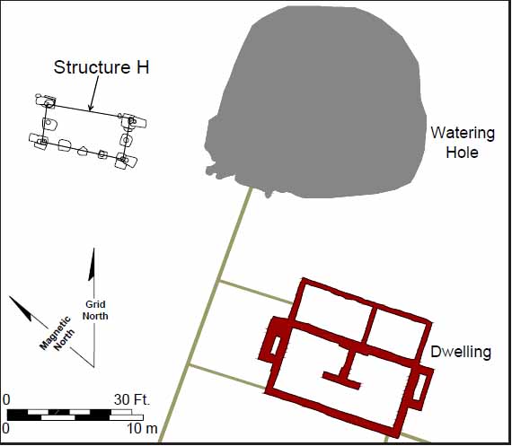 Figure 79. Plan view of Structure H.
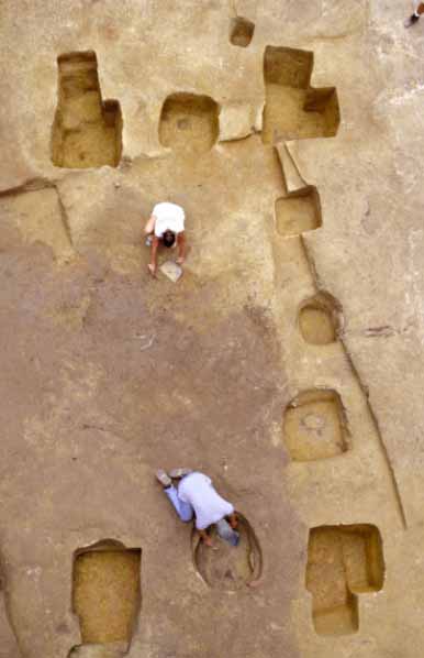 Figure 80. Overall of Structure H.
75
rounded-corner square holes were excavated just around the post needing replacement. These holes measured 10 to 15 inches across and contained large circular molds 8 to 10 inches across. These replacement holes also extended to the depth of the original hole.
Figure 80. Overall of Structure H.
75
rounded-corner square holes were excavated just around the post needing replacement. These holes measured 10 to 15 inches across and contained large circular molds 8 to 10 inches across. These replacement holes also extended to the depth of the original hole.
The interior holes were smaller and shallower than the original corners, measuring 32 inches across and ranging from 16 to 20 inches in depth. Their circular molds measured 10 to 12 inches across. The irregular plan shape of some of these holes is excavation-related and not associated with their original appearance.
Watering Hole
The former clay quarry pit located east of the dwelling continued its role as watering hole throughout the Ludwell period (Figure 81), though in order to construct the additions to the dwelling the west end of this feature was purposely filled with a layer of brick rubble which shifted the entire feature to the east.
The Human Burial
Excavation revealed a burial (68AT-453) between Structure C and Structures E and F (Figure 82). The grave shaft first appeared at the interface of the plowzone and subsoil. The department's best excavator, Lucie Vinciguerra, drew, photographed, and carefully excavated the burial. Grave fill was screened through 1 8-inch wire mesh and soil chemistry samples and pH readings (6.6) were taken from the upper fill. She made several additional drawings documenting organic stains that were almost all that remained of the human remains. Conservator Emily Williams consolidated all fragments of bones in situ with 10% solution of paraloid B72 in 1 to 1 acetone to ethanol. She pedestaled the long bones and removed them in plaster jackets. She removed the grave fill around the head, for later excavation in the conservation lab. This excavation revealed several deteriorated sections of skull and fourteen whole or partial teeth. Dr. Douglas Owsley and D. Hunt of the Smithsonian Institution examined the remains in situ and later again in the laboratory.
Oriented roughly east-west, the individual's head was at the west end (25° south of west). The grave shaft was rectangular in shape and measured 65 by 28 inches. The shaft had vertical sides and a flat bottom. A gray body stain appeared after excavating 10 inches of fill. Overall depth measured approximately 14 inches below plowzone.
Vinciguerra divided the grave fill into two layers. The upper layer was a mixture of yellowish brown clay loam with a light yellow brown sandy clay loam mottling, measured 10 inches deep, and completely sealed the lower fill. The lower fill was similar to the upper fill except for an increase in mottling and the presence of a gray body stain.
Artifacts found in the grave fill included a single nail located at the interface of the grave and subsoil. Excavation revealed no grave goods.
The bones were oriented roughly east-west with the head at the west end. Within the gray body stain some small fragments of spongy bone were found. The body appeared supine, extended, with its feet together, elbows at its sides, and with its hands on its lower abdomen. No evidence of a coffin or a shroud was present. The remains were of an individual with a small frame, approximately 56 inches tall and 18 inches wide from elbow to elbow.
76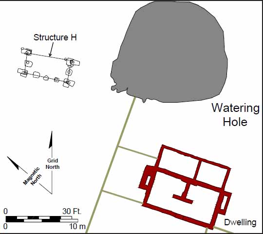 Figure 81. Plan view of watering hole.
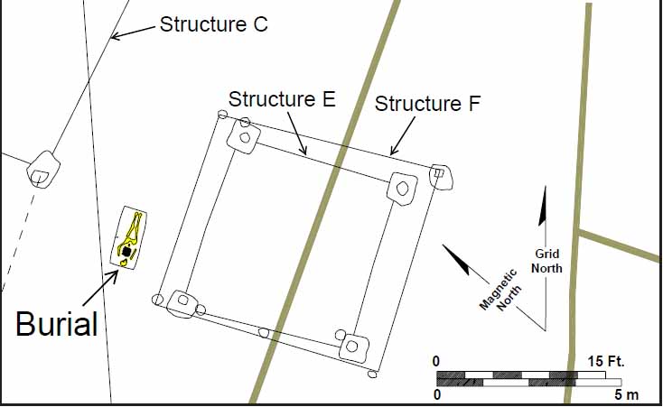 Figure 82. Human burial.
Dr. Owsley argued that this individual was approximately 10-12 years old, and possibly female. Several characteristics from the recovered teeth suggest that this individual had a probable African ancestry. The location of the grave and the lack of a coffin or shroud support this interpretation. The positioning of the grave suggests it was dug while the surrounding structures (Structures C, E, and F) were occupied, sometime between 1665 and ca. 1690. Documents show that during this time the plantation was home to a number of slaves.
Enclosures
Thomas Ludwell not only made changes to the brick structures, he transformed the landscape around them as well. Workers filled in the northern half of the bounding ditch and tore down the two fences that tied into it. The northernmost fence gave way to a new fence that tied the northeast corner of the expanded dwelling to the main east-west fence located just north of the brick structures.
Workers tore down the western half of the main east-west fence in order to make way for the new post buildings. They replace this portion of fence with a new fence located just to the south, which connected the northwest corner of the expanded kitchen structure with the southern portion of the bounding ditch. They also installed two new fences that subdivided the southern portion of the property for the first time. The easternmost of these connected the southwest corner of the dwelling to the southern portion of the ditch. Parallel to it was a fence that connected the new east-west fence to the southern portion of the ditch. This fence contained a gate at its northern end, allowing access from the kitchen into the westernmost part of the site.
The site's only post and rail fence ran northward from the northeast corner of Structure C. The northern end of this fence was not identified and its function remains unclear.
Trash Disposal
The Thomas Ludwell period also witnessed changes in the trash disposal patterns. Waste from the dwelling ended up in three distinct places. Ludwell's workers who exited the rear door used both the barrow pit directly east of the structure. Those who exited from the front door carried trash to the south side of the house or farther south to the bounding ditch. Trash produced in the kitchen exited the building through the door just west of the hearth and was distributed throughout this yard from the small enclosed area just west of the building all the way to the bounding ditch.
Discussion
When Thomas Ludwell purchased Rich Neck in 1665, the plantation was probably in desperate need of repair. The brick structures were around 25 years old, with no owner likely present on the property during the dozen years since Lunsford's death sometime around 1653. To complicate matters, within a year of Ludwell's purchase a massive hurricane destroyed most of Virginia's standing structures. While the brick structures were not destroyed, they were probably damaged and the small Lunsford- 78 period post structure was probably in ruins. With the arrival of Ludwell, Rich Neck underwent a revitalization of massive proportions. Both brick structures underwent complete renovations. It is telling that Ludwell did not dismantle the kitchen entirely and restart from scratch. Intact brickwork, no matter how mediocre, was still valuable. The creative renovation of this structure testifies to the expense associated with manufacturing bricks and employing brick masons in seventeenth-century Virginia.
The number of inhabitants at the site reached its apex during Thomas Ludwell's occupancy. Not only were there more standing structures during his tenure, but the size of the kitchen's hearth and root cellars grew in size as well. While Rich Neck had likely always been home to people of African origin, documents suggest that the number of slaves grew during the Ludwell years as well.
The Ludwell period also witnessed the introduction of separate living quarters for different social groups at Rich Neck. By 1665, masters of large plantations had removed almost all indentured servants and slaves from their dwellings. Post-1660 probate inventories of affluent landowners rarely list servant related furniture or living spaces within a plantation's principal dwelling, suggesting that few, if any, laborers were quartered or took meals under the same roof as their masters (Coombs 2001).
It appears that Ludwell used the kitchen to house the bulk of his servants. Excavation unearthed a large numbers of domestic artifacts around this structure, including table glass, mirror glass, medicinal artifacts, musical instruments (jaw harps), and sewing-related artifacts. This newly renovated space would have been able to house a large number of people, while still fulfilling its other duties as kitchen, storage site, and workspace.
Ludwell seems to have relegated his slaves to the post structures located on the northwestern side of the complex. Architectural attributes and artifact distributions indicate that Structures C, E and F were domestic spaces. While the finds were clearly domestic in nature, this area contained the lightest distribution of artifacts on the entire site, suggesting the material life of the occupants of these structures was meaner than that experienced by their contemporaries living in the kitchen. It is unclear whether Structure D housed slaves or was an agriculture related structure.
Significantly, Ludwell instituted the first physical barriers separating social groups during this period. Before 1665, all of the plantation's residents lived within a unified enclosed area. Ludwell's tenure witnessed the removal of some residents to the outlying periphery of the homelot. To accommodate this new arrangement, he reduced the enclosed area in size, with the longstanding east-west fence marking the northern edge of the enclosed space instead of the northern section of boundary ditch. The ditch remained in place on the southern side of the enclosure. Ludwell instituted further changes west of the kitchen, where a new fence connected the north wing of the newly expanded kitchen to the southern portion of the bounding ditch. This new alignment made room for Structures C, D, E and F to be built close to the master's dwelling but outside the enclosed space. The overall affect of the changes was that Rich Neck's master and his English servants lived within the enclosed space, while slaves were relegated to areas outside the enclosure behind the kitchen.
Grazing Area
Ludwell created a large L-shaped enclosure in the southern half of the site using two fences and the bounding ditch. The north-south fence that connected the dwelling to the southern boundary ditch made up the eastern boundary of this delineated space. The bounding ditch made up the southern boundary, while the north-south fence located just west of the kitchen made up the western limit, and ran from the ditch to the main east-west fence. Phytoliths present in this area were mostly panicoid/chloridoid, with some chloridoid/pooid and pooid (Figures 83 and 84). This suggests the area was made up of a mixture of wet and dry areas. Chloridiods are indicative of a hot, open, arid shortgrass pasture. This enclosed space may have served as a temporary animal penning area. Documentary evidence occasionally describes planters penning cows with calves close to the house for milking (Sullivan 1999).
Structure H
The dating of Structure H hinges on pipestems and artifacts associated with the renovation of the dwelling house. Roofing tile fragments were found in the earliest postholes of this structure, suggesting a post-1665 construction date. Pipestem dating confirms that this structure went up shortly after Ludwell arrived at Rich Neck, and indicates that the building went down sometime around 1681, or shortly after Ludwell's death.
Understanding Structure H's role in the new socially divided world created by Thomas Ludwell is difficult. It shared attributes with structures located inside the enclosure as well as those located on the outside. Complicating the task of determining the status of the occupants who lived in this structure is the presence of artifacts that predate its construction. Pipestem analysis shows that while some pipestems with 8 64th-inch bores clustered around the structure, the vast majority of pipestems found have 6 64th-inch and 7 64th-inch bores, suggesting they were thrown away while Structure H was standing (Figure 85). This data indicates that most of the artifacts found around the structure date to the period it was actively occupied.
Another indication that most of the finds unearthed in this area are not related to the brick dwelling is that artifacts found in and around the main house are missing from the area surrounding Structure H. Included in this group of missing artifacts are plaster, aiglets, curtain rings, locks, keys, and spurs (Figures 86 and 87). Clearly, if the artifacts found around Structure H originated from the main house, these categories of artifacts would have been present.
Structure H resembles the post structures located to the west in several respects. It is, for instance, made of the same material and in the same manner as Structures C, D, E and, F, including dirt floors and no sign of fireplaces. Four of these structures appear to have been built around the same time. Although shaped differently, Structure H's square footage is very similar to Structures D and E, and like the others, it was located just outside the enclosure.
However, Structure H also differs from its wooden contemporaries. Architectural artifacts found around it include window leads and flat glass, suggesting it had glass windows, a first for Rich Neck's wooden structures. It was also repaired twice instead of being replaced, suggesting that it continued to have value even though its
80
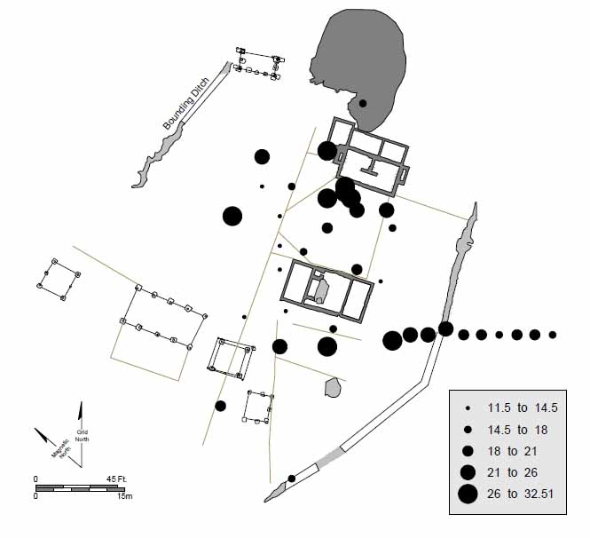 Figure 83. Paniciod distribution.
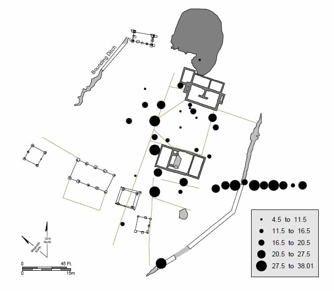 Figure 84. Chloridoid distribution.
81
Figure 84. Chloridoid distribution.
81
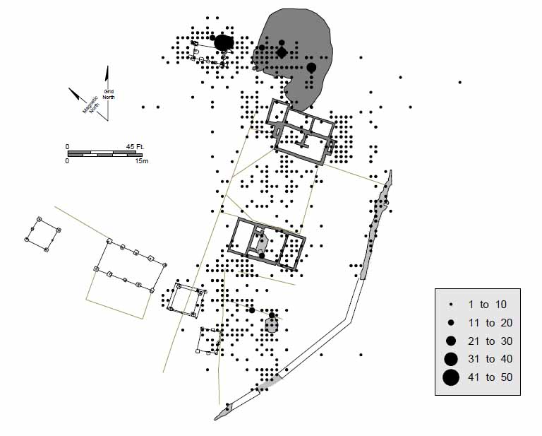 Figure 85. Distribution of 7/64-inch diameter pipestems.
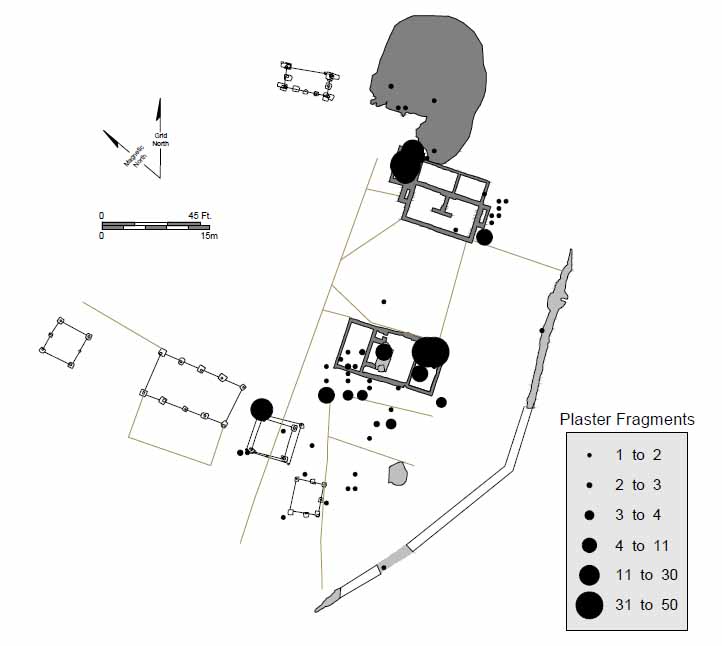 Figure 86. Distribution of plaster around the dwelling.
82
Figure 86. Distribution of plaster around the dwelling.
82
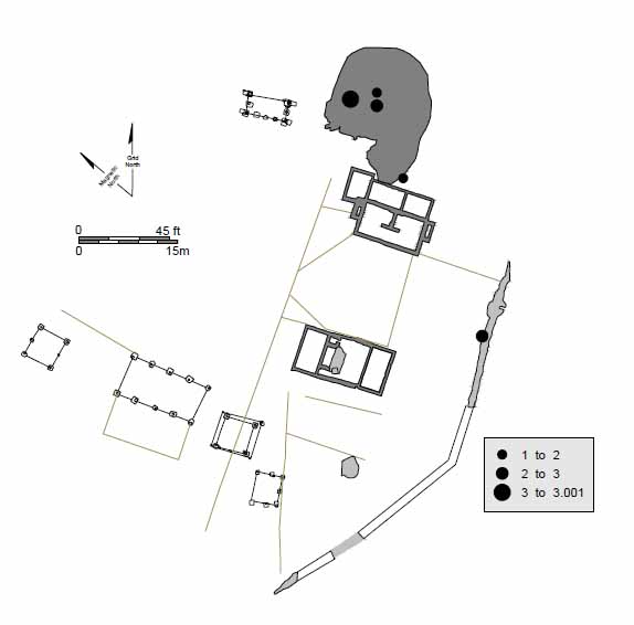 Figure 87a. Distribution of aiglets around the dwelling.
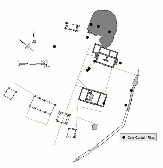 Figure 87b. Distribution of curtain rings around the dwelling.
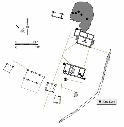 Figure 87c. Distribution of locks around the dwelling.
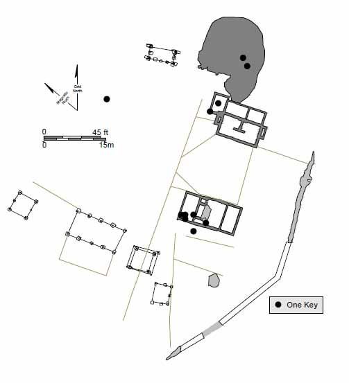 Figure 87d. Distribution of keys around the dwelling.
83
Figure 87d. Distribution of keys around the dwelling.
83
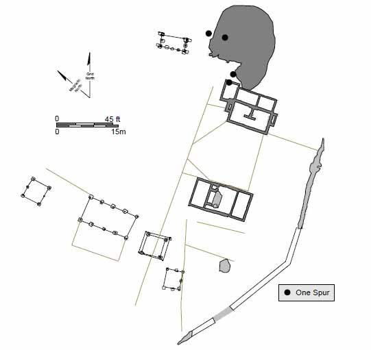 Figure 87e. Distribution of spurs around the dwelling.
placement in a filled ravine contributed to its need for additional repairs (Figure 88). Lastly, the other wooden structures cluster around the back of the kitchen, while Structure H stood alone, near the dwelling.
Figure 87e. Distribution of spurs around the dwelling.
placement in a filled ravine contributed to its need for additional repairs (Figure 88). Lastly, the other wooden structures cluster around the back of the kitchen, while Structure H stood alone, near the dwelling.
An examination of the artifacts found around Structure H points to another difference between it and the other wooden structures. Not only are there more artifacts situated around Structure H, but artifacts not found in association with Structures C, D, E, and F are present, including some status-related items such as cutlery, porcelain, silver jewelry, and horse furniture. However, Structure H was lacking in artifacts usually associated exclusively with elite living such as aiglets, curtain rings, candlesticks, book clasps, and spurs.
Structure H's occupants seemed to have lived in something of a liminal space, removed from the slave quarter's physical community, yet not fully in the masters' domestic enclosure. The structure's post-in-ground architecture suggest that it was a slave dwelling, but its markedly larger and more valuable artifact assemblage stands in direct contrast with the sparseness of the other dwellings' artifacts. Whoever lived in Structure H—be they a group or an individual—appear to have been favored materially during Ludwell's tenure. While the eighteenth and nineteenth centuries' documentary and archaeological records abound with evidence of specially-favored slaves and close personal master-slave relationships, the evidence for the late seventeenth century (a time when Virginia slavery was both new and rare) is less telling. The Ludwell records contain no slave manumissions—a good indicator of a special master-slave relationship—and indeed say little of Ludwell and his slaves. Nevertheless, Structure H's plowzone evidence and its site placement do suggest that its 1670s residents enjoyed a more comfortable material life than did residents of the site's other contemporaries post-in-ground buildings.
84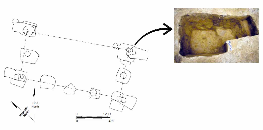 Figure 88. Closeup of repairs to Structure H.
| Structure H | Structures C,D,E,F | |
| Beads | Y | Y |
| Buttons | Y | Y |
| Copper fragments | Y | N |
| Knives | Y | N |
| Forks | Y | N |
| Spoons | Y | N |
| Domestic pipes | Y | Y |
| Horse related | Y | N |
| Window glass and leads | Y | N |
| Metal pots | N | Y |
| Mirror glass | Y | Y |
| Pharmaceutical bottles | Y | Y |
| Straight pins | Y | N |
| Porcelain | Y | N |
| Silver artifacts | Y | N |
| Aiglets | N | N |
| Book clasps | N | N |
| Candlesticks | N | N |
| Curtain rings | N | N |
| Locks and keys | N | N |
| Spurs | N | N |
| Pewter | Y | N |
| Table glass | Y | Y |
Courtyard Plan
During the Lunsford period, Rich Neck's homelot was organized in an I-shaped plan with all three buildings aligned in a single line (Figure 89). Almost all English and Middle Plantation sites from this period employing the linear I-plan placed the outbuildings lined up behind the dwelling. Rich Neck was different in that employed this design with the dwelling and kitchen facing each other and the smaller outbuilding located behind the kitchen.
Ludwell transformed Rich Neck into a true courtyard plan with parallel ranges of outbuildings extending off a shortened I-shaped plan made up of the dwelling and the kitchen. The southern extension included Structures E, F, C and D. Structure H made up the incomplete northern line of structures.
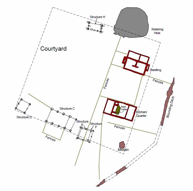 Figure 89. Overview of Ludwell's courtyard plan.
Chapter 6.
Philip Ludwell/Philip Ludwell II Occupancy and Ownership (1674-1694)
Thomas Ludwell's younger brother Philip was also born in Bruton, Somersetshire, and arrived in Virginia in 1660. With a cousin as Governor and an older brother as Secretary of the Colony, it was not long before Philip also began to acquire offices and prestige. He was soon distinguished by the military title of Colonel—an indication that he was a militia leader and important planter. In 1667, he further secured his position in Virginia by marrying Lucy Bernard, a wealthy widow and mistress of Fairfield in Gloucester County. A 1671 document makes reference to Capt. Ludwell's overseer in Gloucester (Billings 1975:203). In 1674/5 Philip was appointed to the Council, and by 1676/7 he was a Deputy Secretary. Around this time he returned to Rich Neck with his son. After his brother died in 1678, he inherited Rich Neck and ascended himself to the post of Secretary (Kukla 1981:89, 91).
Philip played an active role in Bacon's Rebellion, and was one of Governor Berkeley's most ardent supporters. He took refuge with Berkeley on the Eastern Shore and later reported that his property had been plundered. He married Berkeley's widow Francis in 1680, and later moved to Greensprings, Governor Berkeley's plantation. Philip returned to England in 1694 and remained there until his death in 1714.
His son, Philip Ludwell II, was born at Fairfield in 1672, but relocated to Rich Neck with his father after the death of his mother Lucy Higginson Burwell Bernard. He appears to have returned to Rich Neck upon reaching his majority. In 1694, after his father returned to England, Philip II moved back to Greensprings, leaving Rich Neck once again without a resident owner (McCartney n.d.).
Philip II followed in the footsteps of his uncle and father. Chosen Speaker of the House at age 23, he was the youngest person ever to hold this office.
Archaeological Features
Site changes during the Philip I/II tenure can be characterized by two distinct traits. The dwelling house became even more complex with the construction of yet another room. For the rest of the site, however, simplification was the order of the day, and features not oriented with the structures were eliminated or replaced (Figure 90).
Dwelling House
The final addition to the dwelling was a room off the northeast corner (Figure 91). This 1½ course wide foundation measured 10 feet by 12 feet. Beneath the new room was a full cellar, featuring a brick floor and plastered walls (Figure 92). Stratigraphically this room postdates both the additions and the end chimneys, with its builder's trench having a TPQ of 1670. The only heat source for the room and its cellar was the chimney wall of the fireplace attached to the north end of the dwelling's front room.
88
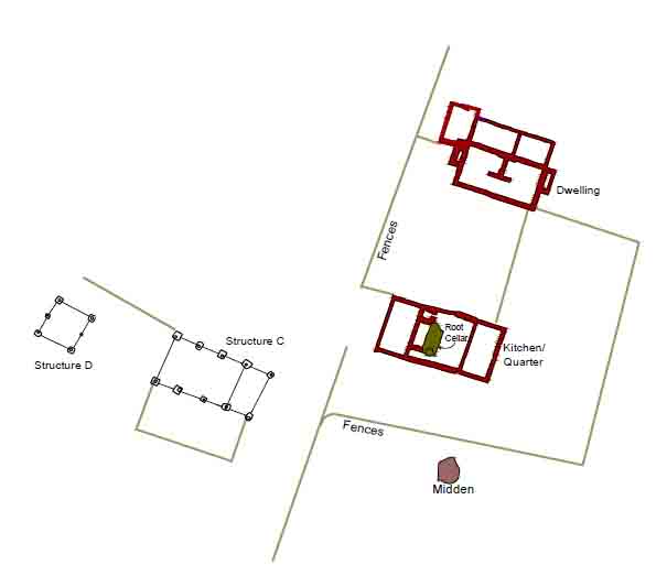 Figure 90. Philip/Philip II's Rich Neck.
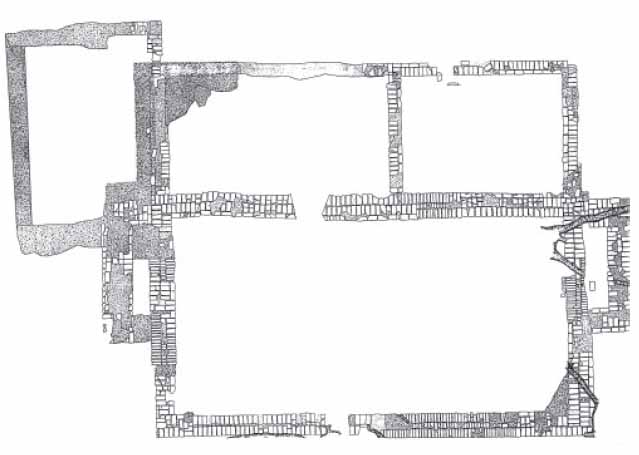 Figure 91. Brick by brick of dwelling house.
89
Figure 91. Brick by brick of dwelling house.
89
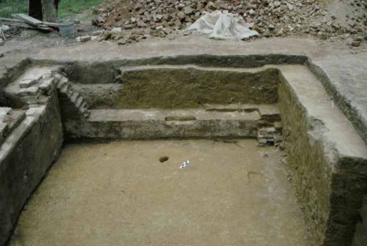 Figure 92. Cellar of the last room added to the dwelling.
The destruction fill in the cellar contained watertable bricks, indicating that it was executed entirely in brick.
Figure 92. Cellar of the last room added to the dwelling.
The destruction fill in the cellar contained watertable bricks, indicating that it was executed entirely in brick.
The foundation walls and floor were both heavily robbed, leaving little evidence about how the cellar was accessed. The floor of the first story would have been raised at least two feet above current ground level, so that adults would have been able to walk upright in the cellar. The first floor was accessible only from the exterior and the room located just to the south, with entry from the main portion of the house being blocked by the chimney. The elevated floor would have made access from the neighboring room to the south difficult, suggesting that that access to the newest addition was limited to an exterior entryway.
The Rest of the Site
Two structures and several features came to an end during this period. Some were simply abandoned, while others were replaced. The last surviving portions of the bounding ditch were filled in. The Ludwells allowed the bottom of the ditch to silt in naturally, before being filled all at one time. They replaced the southern end of the ditch with a fence that connected the fence running south from the dwelling house to a new complex of north-south fences just east of the kitchen midden.
Philip I and II also witnessed the filling of the watering hole. Several layers were identified in the pit, including a brown sandy loam layer that contained large amounts of trash generated from the dwelling. The TPQ for this layer is 1675 and the Binford pipestem date is 1673 (Figure 93). Under the brown loam was a yellow clay fill, possibly originating from the construction of the cellar addition to the dwelling. Under the clay were several ash lenses, a layer containing large amounts of brick, and silt
90
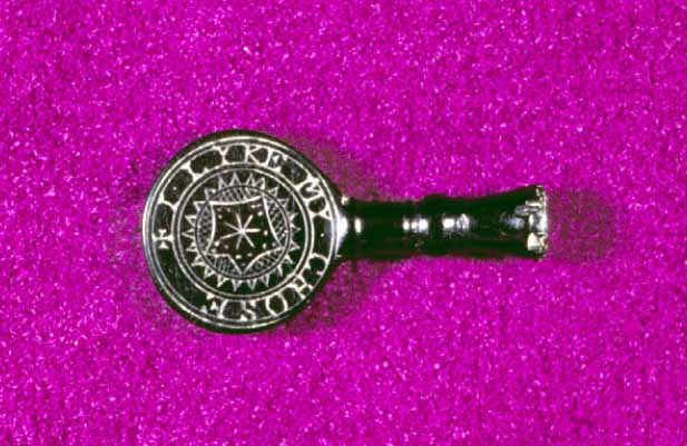 Figure 93. Pipe tamp found in filled-in watering hole.
layers that predate the Philip I/II years. The long-standing east-west fence was extended into the area once the watering hole was filled.
Figure 93. Pipe tamp found in filled-in watering hole.
layers that predate the Philip I/II years. The long-standing east-west fence was extended into the area once the watering hole was filled.
Structures F and H were abandoned and torn down during this period. The area around Structure H saw little activity after it was demolished. The area west of the kitchen, however, was completely reorganized. The area formerly occupied by Structure F became the site of the new main east-west fence (Figure 94). The old main east-west fence had connected the kitchen to the bounding ditch. The filling of this ditch required that a new east-west fence to take the place of the ditch. The destruction of Structure F allowed the fence which divided the slave quarter from the rest of
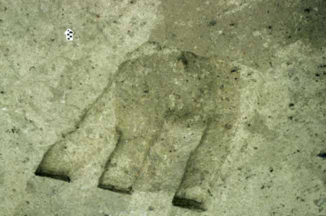 Figure 94. Slot fences cutting Structure F posthole.
91
the site to shift northward. Connecting to this new fence were a series of north-south fences erected just east of the kitchen midden.
Figure 94. Slot fences cutting Structure F posthole.
91
the site to shift northward. Connecting to this new fence were a series of north-south fences erected just east of the kitchen midden.
Discussion
The impact of these changes was to simplify the look of the homelot and to make it more symmetrical and ordered. Philip I/II eliminated features that were not oriented with the structures, including the surviving portions of the bounding ditch and the western portion of the main east-west fence. New and replacement fences were aligned with the structures. This movement towards symmetry may be a precursor to the balance, regularity, and proportion required by the Georgian architecture of the eighteenth century.
The population of the site likely dropped during this period. The loss of 50% of slave housing suggests that may have been relocated elsewhere, perhaps to an outlying quarter (Figure 95). Documents indicate satellite slave quarters were being built at remote locations on the 3500-acre plantation. The reduction in slave housing near the homelot may once again be a precursor to an eighteenth-century trend, the complete spatial separation of a master's domestic space from the living quarters of their slaves.
**********
After 1694 Rich Neck was a different place. Owners after this year were absentee, living at other plantations. The brick structures were old fashioned and probably in ill repair. With no one left to live in them, they quickly turned to ruins. The brick buildings' cellars were filled in sometime after they were abandoned. For example, someone filled the root cellar in Structure A sometime after 1720. The brick cellars filled in over
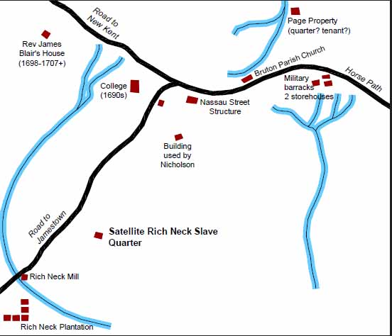 Figure 95. Location of Rich Neck's satellite slave quarter.
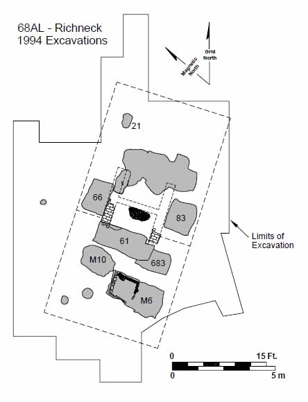 Figure 96. Overall of 1740s Rich Neck slave quarter.
92
time, mostly with brickbats and tiles broken and thrown away during the recycling of bricks.
Figure 96. Overall of 1740s Rich Neck slave quarter.
92
time, mostly with brickbats and tiles broken and thrown away during the recycling of bricks.
The structure's bricks were recycled for years to come. One of the first places to take advantage of this resource was the 1740s slave quarter established just north of the site (Figure 96). Bricks continued to be robbed and sold into the twentieth century. Colonial Williamsburg was probably the last recipient of Rich Neck bricks. The owner of the site in the 1980s recalled his father sending his man and a mule to harvest bricks for a new brick-hungry museum (Vernon Geddy Jr., personal communication).
Around 1694, someone demolished the remaining post structures. The postmolds for these buildings contain used roofing tiles, indicating that they went down around the same time as the roofs were ripped off the dwelling and kitchen.
Replacing this complex was a slave quarter located just to the north. Two features associated with this quarter were excavated on the site. The first was a large trash pit located in the road cut in 1993. The second feature was a post and rail fence that bisected the garden area between the dwelling and the kitchen. The postholes of this fence contained creamware, a common artifact on the eighteenth-century quarter.
93Afterword
The excavations undertaken at Rich Neck revealed an archaeological site of remarkable scope, integrity, and importance. The site is made up of eight known structures, a brick kiln, several refuse areas, and hundreds of landscape features (Figures 97 and 98). Rich Neck represents a plantation homelot rather than a single dwelling, with the houses and artifacts of owners and servants intact. It was built and occupied in the 1640s and survived until near the end of the seventeenth century. With no subsequent occupation or disturbance other than plowing, the site is something of a time capsule. Plowing has mixed the layers that covered the site and slightly truncated some features, but few features appear destroyed. By excavating the site in one-meter squares, data from both the features and the layers combined by plowing was retrieved. Add an extensive historical dataset about Rich Neck's owners and the Rich Neck dig provides a once-in-a-lifetime opportunity to understand life in seventeenth-century Virginia. The excavation of the plowzone in small units was critical to the success of this project. Excavating a plowed site is deceivingly easy; strip the plowzone, and dig the features. The problem with this approach is that data loss can be extensive. Hopefully, this report has illustrated the value of retrieving data from the plowzone. By combining the information found in the plowed layers with feature data a richer, more robust interpretation is possible.
94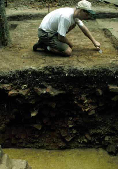 Figure 97. John Coombs excavating Structure A cellar.
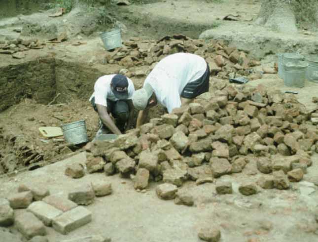 Figure 98. Excavating kitchen cellar.
References
- 1999
- Excavation of a Small Cellar on Rich Neck Plantation. Colonial Williamsburg Archaeological Reports, Williamsburg.
- 1909
- "Sir Thomas Lunsford." Virginia Magazine of History and Biography, 17: 26-33.
- 1911
- Ludwell Family. William & Mary Quarterly, 19 (3, 1st series).
- 1978
- The Size Effect: An Explanation of Variability in Surface Artifact Assemblage Content. American Antiquity, 43: 288-293.
- 1993
- "Politics and Social Structure in Virginia." In Colonial America: Essays in Politics and Social Development, edited by Stanley Katz et al., pp. 17-41. McGraw Hill, New York.
- 1975
- The Old Dominion in the Seventeenth Century: A Documentary History of Virginia, 1606-1689. The University of North Carolina Press for the Institute of Early American History and Culture, Chapel Hill, NC.
- 2001
- Building "the Machine": The Development of Slavery in Colonial Virginia, 1630-1730. The College of William and Mary.
- 1958
- Archeological Excavations at Jamestown, Virginia. National Park Service Archeological Research Series No. 4. National Park Service, Washington, D.C.
- 1971
- Voyages from Holland to America, a.d 1632 to 1644, edited by Henry C. Murphy, pp. 49-50. New York, 1853; reprint 1971.
- 1997
- "Out of Site, Out of Mind: The Archaeology of an Enslaved Virginian Household, ca. 1740-1778. Ph.D. dissertation, University of California, Berkeley.
- 1995
- "A Verie Fit Place to Erect a Great Cittie": Comparative Contextual Analysis of Archaeological Jamestown. Ph.D. dissertation, University of Pennsylvania.
- 1978
- The Homelot on the Seventeenth Century Chesapeake Tidewater Frontier. Ph.D. dissertation, Department of Anthropology, University of Oregon.
- 1988
- A Comparative Middle Analysis of a Houselot and Inn in St. Mary's City. Historical Archaeology, 22. 96
- 1987
- The View from the Midden: An Analysis of Midden Distribution and Variability at the van Sweringen Site, St. Mary's City, Maryland. Historical Archaeology, 21(2): 37-59.
- n.d.
- Site A Interim Report. On file, Department of Archaeological Research, Williamsburg, VA.
- 1981
- Speakers and Clerks of the Virginia House of Burgesses 1643-1776. Virginia State Library, Richmond, Virginia.
- 1981
- Effects of Short-term Tillage on Aggregate Provenience Surface Pattern. In Plowzone Archaeology: Contributions to Theory and Technique, edited by David Lewarch and Michael O'Brien. Vanderbilt University Publications in Anthropology 27, Nashville.
- 1994
- The Excavation of an 18th Century Dutch Yellow Brick Firebox and Chimney Stack in Anne Arundel County, Maryland. Maryland Archaeology, 30(2):9-22.
- 1997
- Cavalier Songs and Ballads of England from 1642 to 1684. Listed on web site, Guttenberg papers.
- 1994
- Archaeological Survey of Holly Hills. Colonial Williamsburg Foundation, Williamsburg.
- n.d.
- History of Rich Neck. On file, Department of Archaeological Research, Williamsburg, VA.
- 1999
- "Early Colonial Gardens." Paper presented at Williamsburg Institute.
- 1976
- Query File. John D. Rockefeller Library, Colonial Williamsburg Foundation.
- 1975
- American Slavery, American Freedom: The Ordeal of Colonial Virginia. W.W. Norton & Company, New York.
- n.d.
- History of Rich Neck. On file, Department of Archaeological Research, Williamsburg, VA. 97
- 1995
- "The Aspirations, Ambience, and Actualities of Middle Plantation." Paper presented at the 28th annual Society for Historical Archaeology conference, Washington, D.C.
- 1993
- Archaeological Testing at Rich Neck. Colonial Williamsburg Foundation, Williamsburg.
- 1992
- Archaeological Testing at Bruton Heights. Colonial Williamsburg Foundation, Williamsburg.
- 1886
- Virginia Carolorum: The Colony Under the Rule of Charles the First and Second A.D. 1625-A.D. 1685. Albany, New York.
- 1980
- The Manner House before Stratford. Robert E. Lee Memorial Association, Stratford.
- 1979
- Cavaliers and Pioneers: Abstracts of Virginia Land Patents and Grants 1623-1666. Volume 1. Originally published 1934. Virginia Book Company, Berryville, Virginia.
- 1977
- Cavaliers and Pioneers: Abstracts of Virginia Land Patents and Grants. Dietz Press, Richmond, Virginia.
- 1996
- The John Page House Site: An Example of the Increase in Domestic Brick Architecture in Seventeenth-Century Tidewater Virginia. M.A. thesis, The College of William and Mary.
- 1988
- Spatial Analysis of King Reach Plantation Homelot. Historical Archaeology, 22(2).
- 1988
- The Interpretation of 17th Century Sites through Plow Zone Surface Collections: Examples from St. Mary's City, Maryland. Historical Archaeology, 22.
- 1990
- New Face on the Countryside: Indians, Colonists, and Slaves in South Atlantic Forests, 1500-1800. Cambridge University Press, New York.
- 1907
- Virginia in 1641-49. Virginia Magazine of History and Biography, 17: 23.
- 1642
- Survey of Richard Kemp's Land. Colonial Williamsburg Research Archives, Williamsburg. 98
- 1999
- Of Panicoids and Pooids: An Environmental Archaeology Study of the Seventeen-Century Houselot at Rich Neck Plantation, Williamsburg, Virginia. M.A. thesis, College of William and Mary.
- 1910
- Sussex in the Great Civil War and the Interregnum, 1642-1660. Chiswick Press, London.
- Virginia General Court Decisions
- 1940
- The First Gentlemen of Virginia: Intellectual Qualities of the Early Colonial Ruling Class. The Huntington Library, San Marino, California.
Appendix 1.
Description of the Richneck Burial
Colonial Williamsburg
D. Owsley and D. Hunt
May 17-18, 1999
RICHNECK-COLW-68AT-453
This poorly preserved skeleton was examined in situ in the field and in the laboratory before, and after, the dentition was removed from the matrix. The remains are in extremely poor condition. Shadow outlines of the cranium, mandible, the diaphyses of the left and right humeri, the distal diaphysis of the right radius or ulna, a small segment of the diaphysis of the left radius or ulna, and the diaphyses of the left and right femora and tibiae were outlined in the soil. In the field, the distal epiphysis of the left tibia also appeared to be present, but not fused to the diaphysis.
The long bones were pedestaled and removed in plaster jackets. Although the general outlines of these elements was preserved, only residual bone is present. The line of union for the greater trochanter epiphysis of the left femur is identifiable and was open. The length of the left femur diaphysis is a little longer than 280 mm, based on a measurement of the preserved outline of bone. The approximate medio-lateral diameter at the midshaft was 26 mm.
The third molar crowns appears to have developmental stage ¾ complete, which indicates an approximate age of 10 to 12 years. The crowns are comparatively small in size indicating sex as possibly female. The occlusal surfaces of the molars are crenulated and show a gradient of increasing size posteriorly. These features suggest probable African ancestry.
Dentition:
Fourteen partial and complete enamel crowns were recovered. The mandibular first and second premolars and second and third molars, the maxillary first premolars and first molars, a left second molar and a probable deciduous right second molar are present. The roots are not preserved. The crowns show almost no wear with only trace polishing of the second mandibular molars and blunting of the left maxillary first molar.
The mandibular first molars do not appear to have been recovered. In situ examination indicated noticeable absence of the left mandibular first molar marked by a space between the second premolar and second molar. The occlusal surface of the maxillary left first molar has a stage 2 cavity and a small pit cavity. Both maxillary first molars are poorly formed with a pronounced hypoplastic line located near the occlusal surface. The presence of defective enamel would predispose these teeth to carious destruction, and may explain the early loss of the mandibular first molars.
The maxillary and mandibular first premolars similarly have a marked hypoplastic line near the occlusal surface. These grooves indicate disrupted enamel formation, probably as a result of childhood illness at the time the first premolars and molars were forming.